File:Manatvs gelegen op de Noot Riuier.jpg

Size of this preview: 800 × 575 pixels. Other resolutions: 320 × 230 pixels | 640 × 460 pixels | 1,024 × 736 pixels | 1,280 × 920 pixels | 2,560 × 1,839 pixels | 8,752 × 6,288 pixels.
Original file (8,752 × 6,288 pixels, file size: 9.24 MB, MIME type: image/jpeg)
Captions
Captions
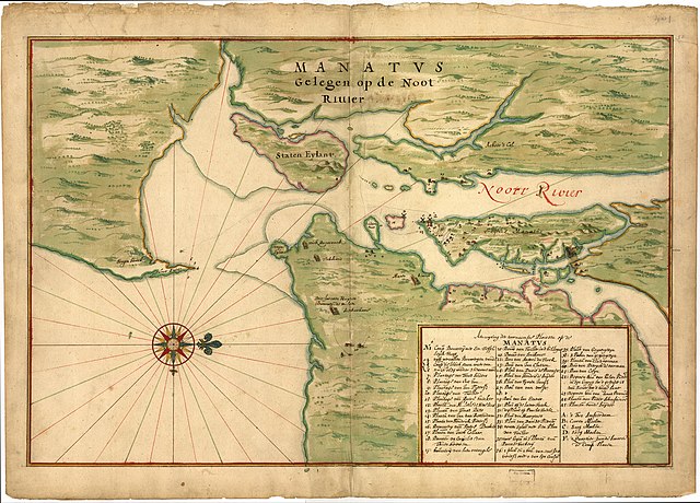
Manatvs (Manhattan) Laying Upon The North River.
| Warning | The original file is very high-resolution. It might not load properly or could cause your browser to freeze when opened at full size. |
|---|
| Description |
"Manatvs gelegen op de Noot [sic] Riuier" - a Dutch map of Manhattan and environs from around 1670, believed to be a copy of a 1639 map often attributed to Johannes Vingboons (a.k.a. Joan Vinckeboons).[1] |
|||||||||
| Date | c.1670 (believed to be a copy of a 1639 map) | |||||||||
| Source | Image of map at Library of Congress ([1]). | |||||||||
| Creator |
sometimes attributed to Johannes Vingboons |
|||||||||
| Geotemporal data | ||||||||||
| Bounding box |
|
|||||||||
| Georeferencing | ||||||||||
- ↑ (2009) Half Moon: Henry Hudson and the Voyage that Redrew the Map of the New World, Bloomsbury Publishing USA, p. 278 ISBN: 1608190986.
|
This work is in the public domain in its country of origin and other countries and areas where the copyright term is the author's life plus 100 years or fewer. | |
| This file has been identified as being free of known restrictions under copyright law, including all related and neighboring rights. | |
File history
Click on a date/time to view the file as it appeared at that time.
| Date/Time | Thumbnail | Dimensions | User | Comment | |
|---|---|---|---|---|---|
| current | 17:03, 17 February 2012 | | 8,752 × 6,288 (9.24 MB) | Gladiool (talk | contribs) | Original, full-resolution image. |
| 00:19, 28 April 2007 |  | 546 × 392 (53 KB) | Mikepanhu (talk | contribs) | {{Information |Description=Joan Vinckeboons (Johannes Vingboon), "Manatvs gelegen op de Noot Riuier", 1639. |Source=[http://lcweb2.loc.gov/cgi-bin/map_item.pl?data=/home/www/data/gmd/gmd380/g3804/g3804n/ct000050.jp2&itemLink=r?ammem/gmd:@field(NUMBER+@ban |
You cannot overwrite this file.
File usage on Commons
The following 3 pages use this file:
File usage on other wikis
The following other wikis use this file:
- Usage on azb.wikipedia.org
- Usage on en.wikipedia.org
- New Netherland
- New York–New Jersey Harbor Estuary
- Jonas Bronck
- Colonial history of New Jersey
- Pavonia, New Netherland
- Bergen, New Netherland
- Communipaw
- User:Djflem
- New Netherland settlements
- Jan Everts Bout
- Hudson Waterfront
- User talk:Vissering
- User:Vissering
- Pietro Cesare Alberti
- Jochem Pietersen Kuyter
- User:Djflem/Holland Tunnel Rotary
- Andries Hudde
- Maryn Adriansen
- Abraham Isaacsen Verplanck
- User:Djflem/Stoffelson
- Talk:Stuyvesant Farm
- Manatus Map
- Cartography of New York City
- New Amsterdam's windmills
- Sawkill mill
- Usage on es.wikipedia.org
- Usage on fr.wikipedia.org
- Usage on he.wikipedia.org
- Usage on ja.wikipedia.org
- Usage on no.wikipedia.org
- Usage on ru.wikipedia.org
- Usage on www.wikidata.org
- Usage on zh.wikipedia.org