File:Mandatory Palestine - Population by Municipality (1945).svg

Size of this PNG preview of this SVG file: 339 × 600 pixels. Other resolutions: 135 × 240 pixels | 271 × 480 pixels | 434 × 768 pixels | 578 × 1,024 pixels | 1,157 × 2,048 pixels | 512 × 906 pixels.
Original file (SVG file, nominally 512 × 906 pixels, file size: 1.44 MB)
Captions
Captions
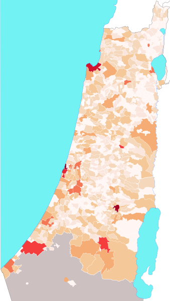
Map of the municipalities in Mandatory Palestine by population count
Summary
edit.svg&action=edit§ion=1)
| Description |
English: Map of the municipalities in Mandatory Palestine by population count
150,000 and more
100,000
50,000
20,000
10,000
5,000
2,000
1,000
500
less than 500
Nomadic regions |
| Date | |
| Source | Own work |
| Author | Bolter21 |
Licensing
edit.svg&action=edit§ion=2)
I, the copyright holder of this work, hereby publish it under the following license:
This file is licensed under the Creative Commons Attribution-Share Alike 4.0 International license.
- You are free:
- to share – to copy, distribute and transmit the work
- to remix – to adapt the work
- Under the following conditions:
- attribution – You must give appropriate credit, provide a link to the license, and indicate if changes were made. You may do so in any reasonable manner, but not in any way that suggests the licensor endorses you or your use.
- share alike – If you remix, transform, or build upon the material, you must distribute your contributions under the same or compatible license as the original.
File history
Click on a date/time to view the file as it appeared at that time.
| Date/Time | Thumbnail | Dimensions | User | Comment | |
|---|---|---|---|---|---|
| current | 19:23, 24 July 2020 | | 512 × 906 (1.44 MB) | Bolter21 (talk | contribs) | Fixed borders for Haifa, Holon and Yafiyye |
| 14:36, 22 July 2020 |  | 512 × 912 (1.39 MB) | Bolter21 (talk | contribs) | Uploaded own work with UploadWizard |
You cannot overwrite this file.
File usage on Commons
There are no pages that use this file.
File usage on other wikis
The following other wikis use this file:
- Usage on en.wikipedia.org
.svg&oldid=880924872)