File:Mankato-New Ulm-North Mankato CSA.png
No higher resolution available.
Mankato-New_Ulm-North_Mankato_CSA.png (440 × 498 pixels, file size: 14 KB, MIME type: image/png)
Captions
Captions
Add a one-line explanation of what this file represents
Summary edit
| Description |
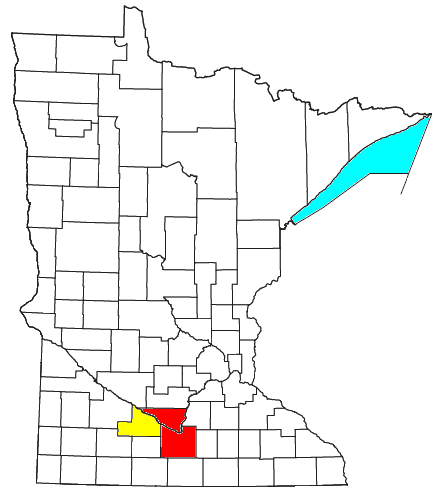
Locator map of the Mankato-New Ulm-North Mankato Combined Statistical Area (CSA) in the southern part of the U.S. state of Minnesota. The two components of the CSA are colored separately: |
| Date | |
| Source | Modified from this United States Census Bureau file, based on this Census definitions list. |
| Author | User:Nyttend, Yassie |
| Permission (Reusing this file) |
US Government work is public domain. Nyttend's work, File:Mankato-North Mankato Micropolitan Area.png, was released into public domain on July 26, 2008. I, Yassie, hereby release my modified work into public domain, too, on January 21, 2019. |
Licensing edit
| I, the copyright holder of this work, release this work into the public domain. This applies worldwide. In some countries this may not be legally possible; if so: I grant anyone the right to use this work for any purpose, without any conditions, unless such conditions are required by law. |
File history
Click on a date/time to view the file as it appeared at that time.
| Date/Time | Thumbnail | Dimensions | User | Comment | |
|---|---|---|---|---|---|
| current | 15:17, 20 January 2019 | | 440 × 498 (14 KB) | Yassie (talk | contribs) | {{Information |Description=Locator map of the Mankato-New Ulm-North Mankato Combined Statistical Area (CSA) in the southern part of the {{w|U.S. state}} of {{w|Minnesota}}. The two components of the CSA are colored separately: *{{w|Mankato – North Mankato metropolitan area|Mankato-North Mankato Metropolitan Statistical Area}}: red *{{w|Brown County, Minnesota|New Ulm Micropolitan Statistical Area}}: yellow |Source=Modified from [http://www2.census.gov/geo/maps/general_ref/cousub_outline/cen2k... |
You cannot overwrite this file.
File usage on Commons
There are no pages that use this file.
File usage on other wikis
The following other wikis use this file:
- Usage on ja.wikipedia.org