File:Mao Kun map - Ceylon, Africa.png

Size of this preview: 448 × 599 pixels. Other resolutions: 179 × 240 pixels | 497 × 665 pixels.
Original file (497 × 665 pixels, file size: 332 KB, MIME type: image/png)
Captions
Captions
Add a one-line explanation of what this file represents
Summary edit
| Description |
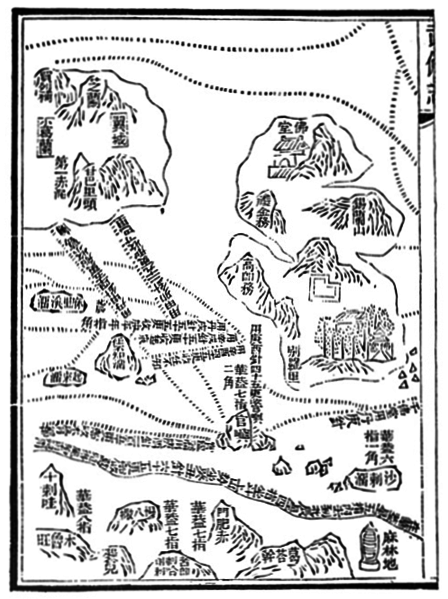
English: Mao Kun map showing Ceylon and east coast of Africa The main island to the right is Ceylon (錫蘭山), India to the left, Africa is shown at the bottom, Malindi (麻林地) indicated at the far right corner |
| Date | 17th century |
| Source | J. V. G. Mills (tr.) Ma Huan: Ying-yai sheng-lan, The overall survey of the ocean's shores. Appendix 2 (1970). Originally from the Wubei Zhi (Treatise on Armament Technology), a 17th century work with maps based on material dated to the early 15th century voyages of Zheng He. |
| Author | Mao Yuanyi (1594–1640?), editor of the Wubei Zhi; and an unknown cartographer. |
Licensing edit
|
This work is in the public domain in its country of origin and other countries and areas where the copyright term is the author's life plus 100 years or fewer. | |
| This file has been identified as being free of known restrictions under copyright law, including all related and neighboring rights. | |
File history
Click on a date/time to view the file as it appeared at that time.
| Date/Time | Thumbnail | Dimensions | User | Comment | |
|---|---|---|---|---|---|
| current | 09:58, 2 August 2015 | | 497 × 665 (332 KB) | Hzh (talk | contribs) | User created page with UploadWizard |
You cannot overwrite this file.
File usage on Commons
There are no pages that use this file.
File usage on other wikis
The following other wikis use this file:
- Usage on en.wikipedia.org
- Usage on es.wikipedia.org
- Usage on it.wikipedia.org