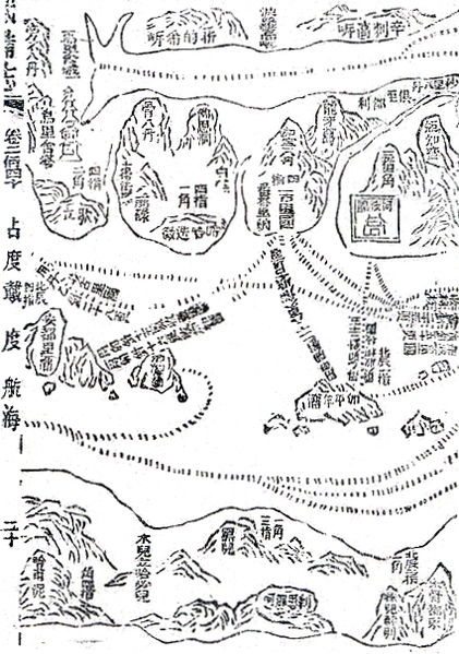
File:Mao Kun map - India, Africa.JPG

Original file (425 × 605 pixels, file size: 334 KB, MIME type: image/jpeg)
Captions
Captions
Summary edit
| DescriptionMao Kun map - India, Africa.JPG |
English: Mao Kun map showing India and east coast of Africa. India is depicted elongated as the map is only interested in the coastal region, therefore the interior is omitted. Among the places shown are Mogadishu (木骨都束) at the bottom right, Orissa (烏里舍塔) on the left near the top, Cochin (柯枝國) on the right within a square, with Calicut (古里國) to its left. |
| Date |
17th century date QS:P,+1650-00-00T00:00:00Z/7 |
| Source | Wubei Zhi (Treatise on Armament Technology), a 17th century work with maps based on material dated to the early 15th century voyages of Zheng He. |
| Author | Mao Yuanyi (1594–1640?), editor of the Wubei Zhi; and an unknown cartographer. |
Licensing edit
| Public domainPublic domainfalsefalse |
|
This work is in the public domain in its country of origin and other countries and areas where the copyright term is the author's life plus 100 years or fewer. | |
| This file has been identified as being free of known restrictions under copyright law, including all related and neighboring rights. | |
https://creativecommons.org/publicdomain/mark/1.0/PDMCreative Commons Public Domain Mark 1.0falsefalse
File history
Click on a date/time to view the file as it appeared at that time.
| Date/Time | Thumbnail | Dimensions | User | Comment | |
|---|---|---|---|---|---|
| current | 16:47, 7 August 2015 |  | 425 × 605 (334 KB) | Hzh (talk | contribs) | User created page with UploadWizard |
You cannot overwrite this file.
File usage on Commons
There are no pages that use this file.
Metadata
This file contains additional information such as Exif metadata which may have been added by the digital camera, scanner, or software program used to create or digitize it. If the file has been modified from its original state, some details such as the timestamp may not fully reflect those of the original file. The timestamp is only as accurate as the clock in the camera, and it may be completely wrong.
| Orientation | Normal |
|---|---|
| Horizontal resolution | 350 dpi |
| Vertical resolution | 350 dpi |
| Software used | Digital Photo Professional |
| File change date and time | 16:24, 15 February 2008 |
| Y and C positioning | Centered |
| Exif version | 2.21 |
| Meaning of each component |
|
| Supported Flashpix version | 1 |
| Color space | sRGB |
| Image width | 1,305 px |
| Image height | 612 px |
| Date and time of digitizing | 21:20, 2 January 2008 |
| Date metadata was last modified | 00:24, 16 February 2008 |
| IIM version | 2 |