File:Map-Germany-1947-2.png
Size of this preview: 706 × 600 pixels. Other resolutions: 283 × 240 pixels | 565 × 480 pixels | 904 × 768 pixels | 1,206 × 1,024 pixels | 2,411 × 2,048 pixels | 3,492 × 2,966 pixels.
Original file (3,492 × 2,966 pixels, file size: 414 KB, MIME type: image/png)
Captions
Captions
Add a one-line explanation of what this file represents
| Description |
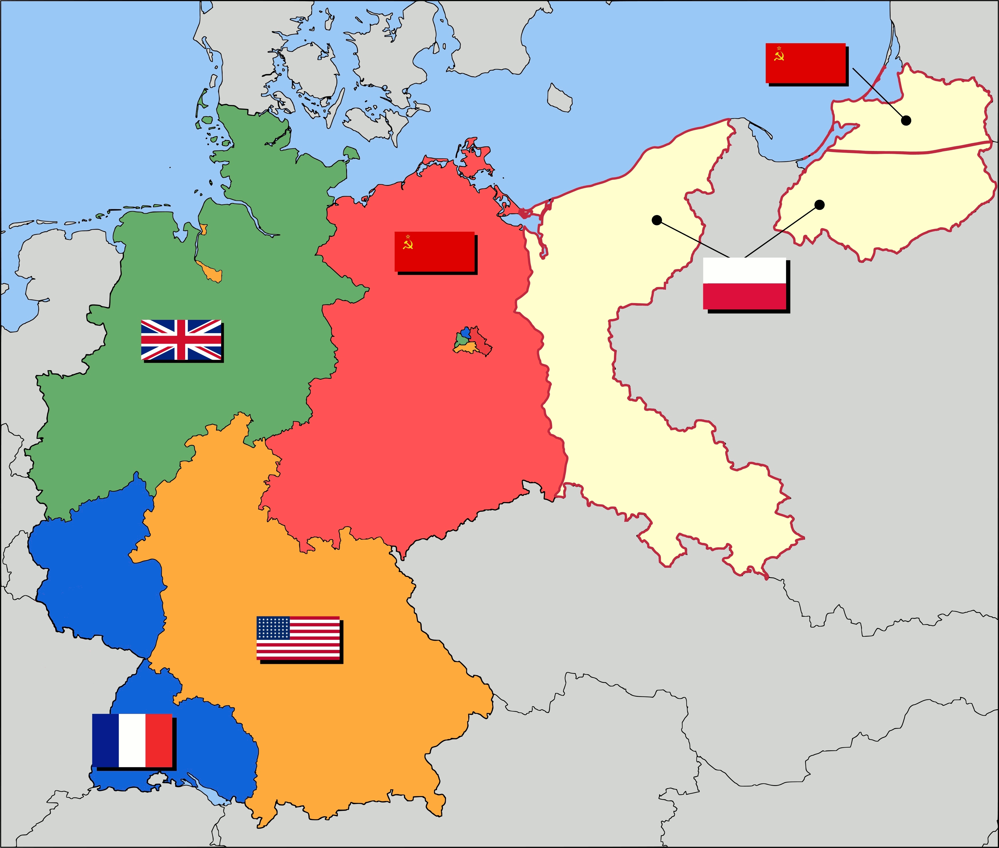
English: Occupation zone borders in Germany, 1947. The territories east of the Oder-Neisse line, under Polish and Soviet administration/annexation, are shown as white. Berlin is the multinational area within the Soviet zone. |
| Date | (UTC) |
| Source | |
| Author |
|
| Other versions |
Derivative works of this file: |
I, the copyright holder of this work, hereby publish it under the following license:
This file is licensed under the Creative Commons Attribution-Share Alike 2.5 Generic license.
- You are free:
- to share – to copy, distribute and transmit the work
- to remix – to adapt the work
- Under the following conditions:
- attribution – You must give appropriate credit, provide a link to the license, and indicate if changes were made. You may do so in any reasonable manner, but not in any way that suggests the licensor endorses you or your use.
- share alike – If you remix, transform, or build upon the material, you must distribute your contributions under the same or compatible license as the original.
Original upload log
edit
This image is a derivative work of the following images:
- File:_Map-Germany-1947.svg licensed with Cc-by-sa-2.5
- 2008-09-15T00:07:20Z Stor stark7 3492x2966 (753330 Bytes) {{Information| |Description= Occupation zone borders in Germany, 1947. The territories east of the [[Oder-Neisse line]], under Polish and Soviet administration/annexation, are shown as white as is the likewise detached [[Saar
Uploaded with derivativeFX
File history
Click on a date/time to view the file as it appeared at that time.
| Date/Time | Thumbnail | Dimensions | User | Comment | |
|---|---|---|---|---|---|
| current | 21:57, 14 May 2009 | | 3,492 × 2,966 (414 KB) | Yumyum73 (talk | contribs) | {{Information |Description={{en|1=Occupation zone borders in Germany, 1947. The territories east of the Oder-Neisse line, under Polish and Soviet administration/annexation, are shown as white. Berlin is the multinational area with |
You cannot overwrite this file.
File usage on Commons
The following 2 pages use this file: