File:Map-koganemaki.jpg
Size of this preview: 293 × 599 pixels. Other resolutions: 117 × 240 pixels | 234 × 480 pixels | 375 × 768 pixels | 1,100 × 2,250 pixels.
Original file (1,100 × 2,250 pixels, file size: 768 KB, MIME type: image/jpeg)
Captions
Captions
Add a one-line explanation of what this file represents
Summary
edit
| Description |
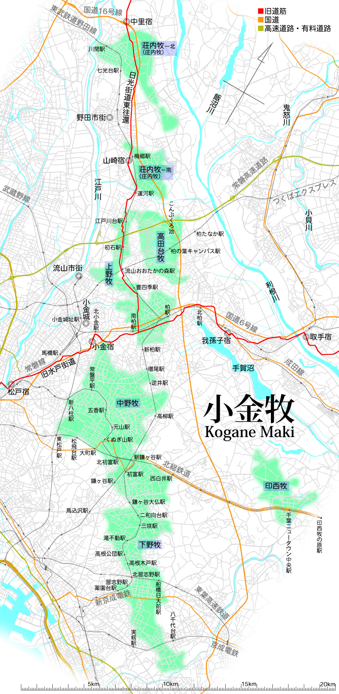
日本語:
小金牧の地図。国土地理院作成地図ベースの現代図を基礎とし、『松戸市史』掲載の小金牧の解説図を重ね、ランドマークとして旧道筋・宿場町・国道・鉄道などを記した。投稿者が作成。
現代図がベースであるため、江戸時代とは、いくつかの点で大きく地形が異なっている。ja:運河駅付近を左右に横切っているja:利根運河は明治時代の開削のため存在しなかった。ja:手賀沼・ja:印旛沼は干拓事業によって大幅に小さくなった。川筋・海岸線にも変化がある。 牧の境界線には野馬土手などと呼ばれる土手が作られ、馬が域外に出ることを食い止めていた。部分的には残っているが、失われたところもあり、厳密な境界はわからなくなっているところも多い。また、多重に野馬土手がめぐらされていた場所もある。そのため、牧の外周部がおおまかであることを示すためにボケエッジとしてある。 メジャーヴァージョンアップ履歴
|
| Georeferencing | If inappropriate please set warp_status = skip to hide. |
Licensing
edit
| This file is licensed under the Creative Commons Attribution-Share Alike 3.0 Unported license. Subject to disclaimers. | ||
| ||
| This licensing tag was added to this file as part of the GFDL licensing update. |

|
Permission is granted to copy, distribute and/or modify this document under the terms of the GNU Free Documentation License, Version 1.2 or any later version published by the Free Software Foundation; with no Invariant Sections, no Front-Cover Texts, and no Back-Cover Texts. A copy of the license is included in the section entitled GNU Free Documentation License. Subject to disclaimers. |
File history
Click on a date/time to view the file as it appeared at that time.
| Date/Time | Thumbnail | Dimensions | User | Comment | |
|---|---|---|---|---|---|
| current | 12:02, 18 February 2009 | | 1,100 × 2,250 (768 KB) | Nekosuki600 (talk | contribs) | |
| 18:10, 20 February 2008 |  | 1,100 × 2,250 (627 KB) | Nekosuki600 (talk | contribs) | 水場のひとつで現存している「こんぶくろ池」が、ver2で消えてしまっていたので、復帰しておきます。 | |
| 03:41, 9 January 2008 |  | 1,100 × 2,250 (769 KB) | Nekosuki600 (talk | contribs) | 微調整(荘内牧の表記併記ほか)。 | |
| 10:26, 27 December 2007 |  | 1,100 × 2,250 (786 KB) | Nekosuki600 (talk | contribs) | ==地図の概要== 小金牧の地図。国土地理院作成地図ベースの現代図を基礎とし、『松戸市史』掲載の小金牧の解説図を重ね、ランドマークとして旧道筋・宿場町・国道・鉄道などを記した。� |
You cannot overwrite this file.
File usage on Commons
The following page uses this file:
File usage on other wikis
The following other wikis use this file: