File:Map-of-Ottoman-Empire-in-1900.png
Size of this preview: 800 × 504 pixels. Other resolutions: 320 × 202 pixels | 640 × 403 pixels | 1,024 × 646 pixels | 1,280 × 807 pixels | 2,652 × 1,672 pixels.
Original file (2,652 × 1,672 pixels, file size: 414 KB, MIME type: image/png)
Captions
Captions
Add a one-line explanation of what this file represents
Summary edit
| Description |
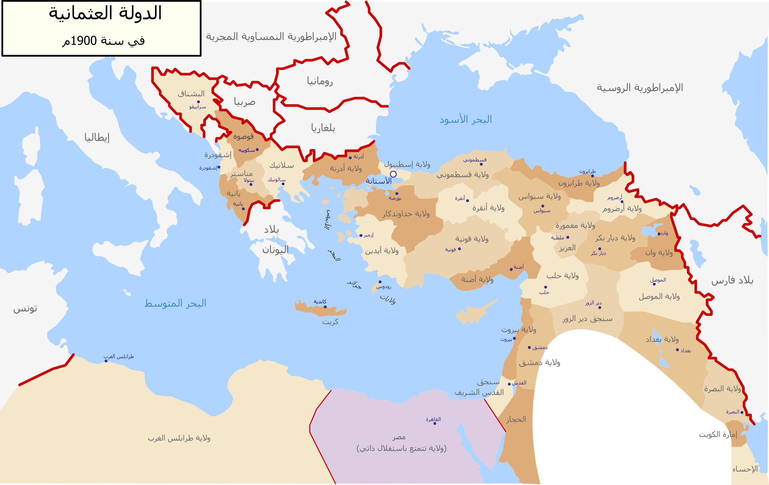
العربية: خارطة تظهر التقسيم الإداري للدولة العثمانية سنة 1900 باللغة العربية |
| Date | (UTC) |
| Source |
This file was derived from: Map-of-Ottoman-Empire-in-1900-German.svg: |
| Author |
|
| This is a retouched picture, which means that it has been digitally altered from its original version. Modifications: translated to Arabic. The original can be viewed here: Map-of-Ottoman-Empire-in-1900-German.svg:
|
Licensing edit
I, the copyright holder of this work, hereby publish it under the following license:
| I, the copyright holder of this work, release this work into the public domain. This applies worldwide. In some countries this may not be legally possible; if so: I grant anyone the right to use this work for any purpose, without any conditions, unless such conditions are required by law. |
Original upload log edit
This image is a derivative work of the following images:
- File:Map-of-Ottoman-Empire-in-1900-German.svg licensed with PD-self
- 2010-09-15T16:03:25Z NordNordWest 2647x1660 (80991 Bytes) c
- 2010-09-15T16:01:51Z NordNordWest 2646x1660 (80490 Bytes) c
- 2010-09-15T16:00:30Z NordNordWest 2646x1660 (81041 Bytes) c
- 2010-08-28T18:30:23Z NordNordWest 2645x1661 (114565 Bytes) bigger
- 2010-08-28T18:18:46Z NordNordWest 885x557 (98596 Bytes) {{Information |Description={{de|Karte des Osmanischen Reiches um 1900 in Deutsch}} {{en|Map of Ottoman Empire (1900) in German}} |Source=*[[:File:Map-of-Ottoman-Empire-in-1900-Latvian.svg|]] |Date=2010-08-28 18:18 (UTC) |Auth
Uploaded with derivativeFX
File history
Click on a date/time to view the file as it appeared at that time.
| Date/Time | Thumbnail | Dimensions | User | Comment | |
|---|---|---|---|---|---|
| current | 17:00, 18 May 2018 | | 2,652 × 1,672 (414 KB) | NordNordWest (talk | contribs) | + Sicily, Sardegna, Corse, Malta |
| 21:26, 5 July 2012 |  | 2,652 × 1,672 (547 KB) | باسم (talk | contribs) | == {{int:filedesc}} == {{Information |Description={{ar|خارطة تظهر التقسيم الإداري للدولة العثمانية سنة 1900 باللغة العربية}} |Source={{Derived from|Map-of-Ottoman-Empire-in-1900-German.svg|display=5... |
You cannot overwrite this file.
File usage on Commons
The following 6 pages use this file:
File usage on other wikis
The following other wikis use this file:
- Usage on ar.wikipedia.org
- الدولة العثمانية
- سلفيت
- صيدا
- الحسين بن علي شريف مكة
- المسيحية في سوريا
- ويكيبيديا:جائزة المنتج - النصف الثاني لعام 2012/باسم
- بوابة:الدولة العثمانية/مقالة مختارة
- التنظيم الإداري في الدولة العثمانية
- قائمة ولايات الدولة العثمانية
- ويكيبيديا:قائمة اليوم المختارة/فبراير 2017
- قالب:قائمة اليوم المختارة/2017-02-13
- بوابة:الدولة العثمانية/مقالة مختارة/32
- ويكيبيديا:قائمة اليوم المختارة/مارس 2017
- قالب:قائمة اليوم المختارة/2017-03-17
- سباق التسلح البحري العثماني اليوناني
- بوابة:تجمعات سكانية/قائمة مختارة
- بوابة:تجمعات سكانية/قائمة مختارة/10
- ويكيبيديا:قائمة اليوم المختارة/يوليو 2017
- قالب:قائمة اليوم المختارة/2017-07-14
- ويكيبيديا:قائمة اليوم المختارة/يناير 2018
- قالب:قائمة اليوم المختارة/2018-01-28
- ويكيبيديا:قائمة اليوم المختارة/مارس 2018
- قالب:قائمة اليوم المختارة/2018-03-15
- ويكيبيديا:قائمة اليوم المختارة/يناير 2019
- قالب:قائمة اليوم المختارة/2019-01-20
- قائمة القوى العظمى الحديثة
- ويكيبيديا:قائمة اليوم المختارة/يونيو 2019
- قالب:قائمة اليوم المختارة/2019-06-29
- ويكيبيديا:قائمة اليوم المختارة/ديسمبر 2019
- قالب:قائمة اليوم المختارة/2019-12-17
- ويكيبيديا:قائمة اليوم المختارة/يونيو 2020
- قالب:قائمة اليوم المختارة/2020-06-14
- ويكيبيديا:قائمة اليوم المختارة/فبراير 2021
- قالب:قائمة اليوم المختارة/2021-02-25
- ويكيبيديا:قائمة اليوم المختارة/أبريل 2022
- قالب:قائمة اليوم المختارة/2022-04-13
- ويكيبيديا:قائمة اليوم المختارة/ديسمبر 2022
- قالب:قائمة اليوم المختارة/2022-12-01
- سنجق القدس
- ويكيبيديا:قائمة اليوم المختارة/يوليو 2023
- قالب:قائمة اليوم المختارة/2023-07-23
- ويكيبيديا:قائمة اليوم المختارة/مارس 2024
- قالب:قائمة اليوم المختارة/2024-03-12