File:Map-pugetsound-vector.svg

Size of this PNG preview of this SVG file: 388 × 600 pixels. Other resolutions: 155 × 240 pixels | 310 × 480 pixels | 497 × 768 pixels | 662 × 1,024 pixels | 1,325 × 2,048 pixels | 792 × 1,224 pixels.
Original file (SVG file, nominally 792 × 1,224 pixels, file size: 6.59 MB)
Captions
Captions
Add a one-line explanation of what this file represents
Summary
edit
| Description |
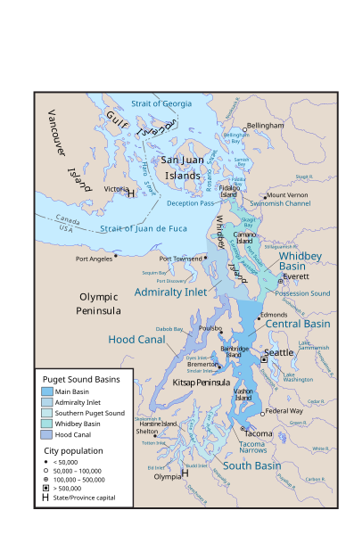
English: Map of Puget Sound and its main basins, along with the Canada-US border. Created with ArcExplorer and Adobe Illustrator. Based on GeoBase and The National Map data. (this is an SVG version of File:Map-pugetsound.png, but did not turn out right—perhaps can figure it out and replace eventually). |
| Source | Own work |
| Author | Pfly |
Licensing
edit
I, the copyright holder of this work, hereby publish it under the following licenses:
This file is licensed under the Creative Commons Attribution-Share Alike 3.0 Unported license.
- You are free:
- to share – to copy, distribute and transmit the work
- to remix – to adapt the work
- Under the following conditions:
- attribution – You must give appropriate credit, provide a link to the license, and indicate if changes were made. You may do so in any reasonable manner, but not in any way that suggests the licensor endorses you or your use.
- share alike – If you remix, transform, or build upon the material, you must distribute your contributions under the same or compatible license as the original.

|
Permission is granted to copy, distribute and/or modify this document under the terms of the GNU Free Documentation License, Version 1.2 or any later version published by the Free Software Foundation; with no Invariant Sections, no Front-Cover Texts, and no Back-Cover Texts. A copy of the license is included in the section entitled GNU Free Documentation License. |
You may select the license of your choice.
File history
Click on a date/time to view the file as it appeared at that time.
| Date/Time | Thumbnail | Dimensions | User | Comment | |
|---|---|---|---|---|---|
| current | 22:41, 22 October 2013 | | 792 × 1,224 (6.59 MB) | Pfly (talk | contribs) | {{Information |Description ={{en|1=Map of Puget Sound and its main basins. Created with ArcExplorer and Adobe Illustrator. Based on GeoBase and [[:en... |
You cannot overwrite this file.
File usage on Commons
There are no pages that use this file.