File:Map Attached to the Protocol. (WOOS-14-1-2-2).jpg

Size of this preview: 501 × 599 pixels. Other resolutions: 201 × 240 pixels | 401 × 480 pixels | 642 × 768 pixels | 856 × 1,024 pixels | 1,712 × 2,048 pixels | 6,464 × 7,731 pixels.
Original file (6,464 × 7,731 pixels, file size: 15.1 MB, MIME type: image/jpeg)
Captions
Captions
Add a one-line explanation of what this file represents
Summary edit
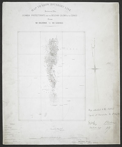
| Title |
'Map Attached to the Protocol. Signed at Busuenda the 4th. May, 1911 E.M. Jack. Major, FRD Prittie Capt., J Bastien, Maury' |
|||||||||
| Description |
Material created or gathered by the Uganda-Congo Boundary Commission, 1906-1908, and by the Anglo-German-Belgian Boundary Commission, 1911 relating to the Uganda-Congo boundary |
|||||||||
| British Library Shelfmark | WOOS/14/1/2/2 | |||||||||
| Locations Depicted | Busuenda, Belgian Congo | |||||||||
| Centre Point Coordinates | -1.1667,29.5833 | |||||||||
| Date | between 1911 and 1912 | |||||||||
| Source |
|
|||||||||
| Creator |
Bastien, J, fl 1903-1911, Belgian army officer, Signer Jack, Evan Maclean, 1873-1951, army officer, Signer Maury, J G, fl 1911, Belgian army officer, Signer Prittie, Hon, Francis Reginald Dennis, 1880-1914, army officer, Signer |
|||||||||
| Permission (Reusing this file) |
|
|||||||||
| Geotemporal data | ||||||||||
| Map location | British East Africa | |||||||||
| Scale | 1:200,000 | |||||||||
| Bounding box |
|
|||||||||
| Georeferencing | If inappropriate please set warp_status = skip to hide. | |||||||||
| Archival data | ||||||||||
| Collection | ||||||||||
| Dimensions | 61 x 50cm | |||||||||
| Medium | Bromides, with manuscript additions in pencil and coloured ink | |||||||||
| Notes | For more information please see the British Library’s Collection Guide to the War Office Archive. Archived from the original on 2016-01-11. Retrieved on 2015-11-25. | |||||||||

.svg)


.jpg&action=edit§ion=1)
.jpg¶ms=-0.8333_N_29.3333_E_)
.jpg¶ms=-0.8333_N_29.8333_E_)
.jpg¶ms=-1.5000_N_29.3333_E_)
.jpg¶ms=-1.5000_N_29.8333_E_)
File history
Click on a date/time to view the file as it appeared at that time.
| Date/Time | Thumbnail | Dimensions | User | Comment | |
|---|---|---|---|---|---|
| current | 08:19, 25 November 2015 | | 6,464 × 7,731 (15.1 MB) | Ndalyrose (talk | contribs) | GWToolset: Creating mediafile for Ndalyrose. |
You cannot overwrite this file.
File usage on Commons
There are no pages that use this file.
.jpg&oldid=837833321)