File:Map Bastimentos PortoBello Panama.svg

Size of this PNG preview of this SVG file: 744 × 422 pixels. Other resolutions: 320 × 182 pixels | 640 × 363 pixels | 1,024 × 581 pixels | 1,280 × 726 pixels | 2,560 × 1,452 pixels.
Original file (SVG file, nominally 744 × 422 pixels, file size: 544 KB)
Captions
Captions
Add a one-line explanation of what this file represents
Summary
edit| Description |
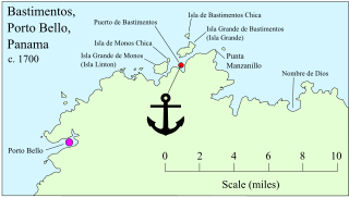
Map of north-east coast of Panama from Porto Bello to Nombre de Dios, based on a Spanish map c.1700, acquired Oct 1927 by the Map Division, Library of Congress, G4874.P6A1 17 P5 Vault (see File:MapCirca1700 Bastimentos Portobelo Panama.png  |
| Date | |
| Source | own work, traced from google maps, using anchor element from File:Aussersihl-blazon.svg by User:Gerhard Bräunlich |
| Author | Lobsterthermidor (talk) 17:33, 3 November 2020 (UTC) |

Licensing
edit
This file is licensed under the Creative Commons Attribution-Share Alike 3.0 Unported license.
- You are free:
- to share – to copy, distribute and transmit the work
- to remix – to adapt the work
- Under the following conditions:
- attribution – You must give appropriate credit, provide a link to the license, and indicate if changes were made. You may do so in any reasonable manner, but not in any way that suggests the licensor endorses you or your use.
- share alike – If you remix, transform, or build upon the material, you must distribute your contributions under the same or compatible license as the original.
File history
Click on a date/time to view the file as it appeared at that time.
| Date/Time | Thumbnail | Dimensions | User | Comment | |
|---|---|---|---|---|---|
| current | 00:49, 4 November 2020 | | 744 × 422 (544 KB) | Lobsterthermidor (talk | contribs) | Spelling corrected to: Isla de Monos |
| 17:28, 3 November 2020 |  | 744 × 422 (547 KB) | Lobsterthermidor (talk | contribs) | Added anchor, and coloured dots, etc | |
| 01:22, 3 November 2020 |  | 744 × 422 (545 KB) | Lobsterthermidor (talk | contribs) | Improved identifying names, per Spanish map c.1700 | |
| 20:58, 2 November 2020 |  | 744 × 422 (321 KB) | Lobsterthermidor (talk | contribs) | {{Information |Description=Map of north-east coast of Panama from Porto Bello to Nombre de Dios, showing the probable location of the place called "Bastimentos" by Christopher Columbus in November 1502 during his 4th Voyage, as recorded by his son Ferdinand: “they put in among islets next to the continent where Nombre de Dios now is and because all these coasts and islets were full of maize they called it Puerto de Bastimentos (Harbour of Provisions)”. In 1508 the inlet or harbour at Bast... |
You cannot overwrite this file.
File usage on Commons
The following page uses this file:
File usage on other wikis
The following other wikis use this file:
- Usage on en.wikipedia.org