File:Map Byzantine Empire 1076-es.svg

Size of this PNG preview of this SVG file: 800 × 450 pixels. Other resolutions: 320 × 180 pixels | 640 × 360 pixels | 1,024 × 576 pixels | 1,280 × 720 pixels | 2,560 × 1,440 pixels | 1,963 × 1,104 pixels.
Original file (SVG file, nominally 1,963 × 1,104 pixels, file size: 90 KB)
Captions
Captions
Add a one-line explanation of what this file represents

Summary
edit| Description |
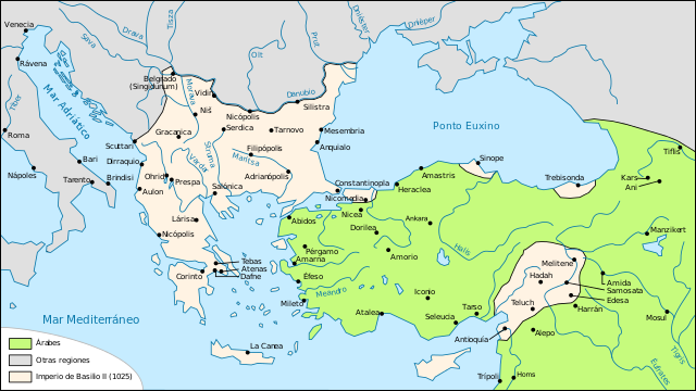
Español: El Imperio bizantino en el 1076.
Français : Carte de l'empire byzantin en 1076 |
| Date | (UTC) |
| Source |
This file was derived from: Map Byzantine Empire 1076-fr.svg: |
| Author | Odejea, Rowanwindwhistler |
| Other versions |
[]
|


| This is a retouched picture, which means that it has been digitally altered from its original version. Modifications: translated into Spanish. The original can be viewed here: Map Byzantine Empire 1076-fr.svg:
|
Licensing
edit
This file is licensed under the Creative Commons Attribution-Share Alike 3.0 Unported license.
- You are free:
- to share – to copy, distribute and transmit the work
- to remix – to adapt the work
- Under the following conditions:
- attribution – You must give appropriate credit, provide a link to the license, and indicate if changes were made. You may do so in any reasonable manner, but not in any way that suggests the licensor endorses you or your use.
- share alike – If you remix, transform, or build upon the material, you must distribute your contributions under the same or compatible license as the original.
Original upload log
edit
This image is a derivative work of the following images:
- File:Map_Byzantine_Empire_1076-fr.svg licensed with Cc-by-sa-3.0,2.5,2.0,1.0, GFDL
- 2012-04-30T20:41:28Z Spiridon Ion Cepleanu 1963x1104 (94694 Bytes) Reverted to version as of 20:55, 12 November 2008
- 2012-04-30T20:40:12Z Spiridon Ion Cepleanu 842x595 (125182 Bytes) Rectification since all historic atlases and also John Haldon : ''Warfare, State And Society In The Byzantine World 565-1204'' (Routledge 1999) ISBN 1-85728-494-1, Maps IV et follow., & Piers Paul Read, "The Templars", London
- 2008-11-12T20:55:40Z Odejea 1963x1104 (94694 Bytes) oups mauvaise version
- 2008-11-12T20:54:56Z Odejea 1963x1104 (95175 Bytes) décalage vert
- 2008-11-12T20:08:05Z Odejea 1963x1104 (95175 Bytes) contour des domaines de Philaretos Brakhamios
- 2008-11-12T20:00:49Z Odejea 1963x1104 (87585 Bytes) {{Information |Description={{fr|1=Carte de l'empire byzantin en 1076}} |Source=travail personnel à partir de [[:Image:Map Byzantine Empire 1025-fr.svg]] |Author=[[User:Odejea|Odejea]] |Date=12 novembre 2008 |Permission= |oth
Uploaded with derivativeFX
File history
Click on a date/time to view the file as it appeared at that time.
| Date/Time | Thumbnail | Dimensions | User | Comment | |
|---|---|---|---|---|---|
| current | 10:21, 21 March 2016 | | 1,963 × 1,104 (90 KB) | Rowanwindwhistler (talk | contribs) | Better colours, some text moved & corrected |
| 20:54, 15 October 2012 |  | 1,963 × 1,104 (94 KB) | Rowanwindwhistler (talk | contribs) | == {{int:filedesc}} == {{Information |Description={{es|1=El Imperio bizantino en el 1076.}} {{fr|1=Carte de l'empire byzantin en 1076}} |Source={{Derived from|Map_Byzantine_Empire_1076-fr.svg|display=50}} |Date=2012-10-15 20:53 (UTC) |Author=*[[:File:M... |
You cannot overwrite this file.
File usage on Commons
The following 10 pages use this file:
- User:J budissin/Uploads/BiH/2016 March 21-31
- User:Jaqeli/Georgia
- File:Bizánc 1076-ban.jpg
- File:Map Byzantine Empire 1076-es.svg
- File:Map Byzantine Empire 1076-fr.jpg
- File:Map Byzantine Empire 1076-fr.svg
- File:Map Byzantine Empire 1076-pt.svg
- File:Map Byzantine Empire 1076-vi.svg
- File:Map Byzantine Empire 1076-zh.svg
- Template:Other versions/Byzantine Empire 1076
File usage on other wikis
The following other wikis use this file:
- Usage on ast.wikipedia.org
- Usage on es.wikipedia.org