File:Map Byzantine Empire 1076-fr.svg

Size of this PNG preview of this SVG file: 800 × 450 pixels. Other resolutions: 320 × 180 pixels | 640 × 360 pixels | 1,024 × 576 pixels | 1,280 × 720 pixels | 2,560 × 1,440 pixels | 1,963 × 1,104 pixels.
Original file (SVG file, nominally 1,963 × 1,104 pixels, file size: 92 KB)
Captions
Captions
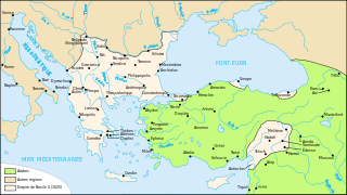
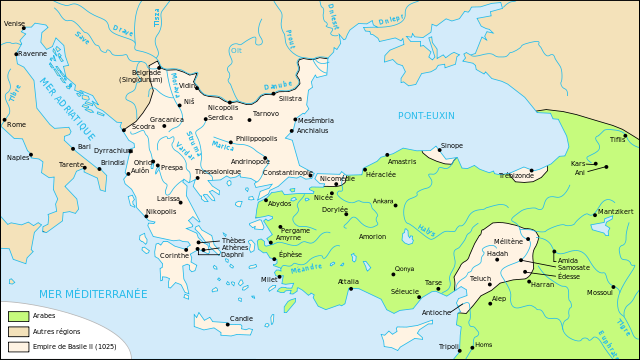
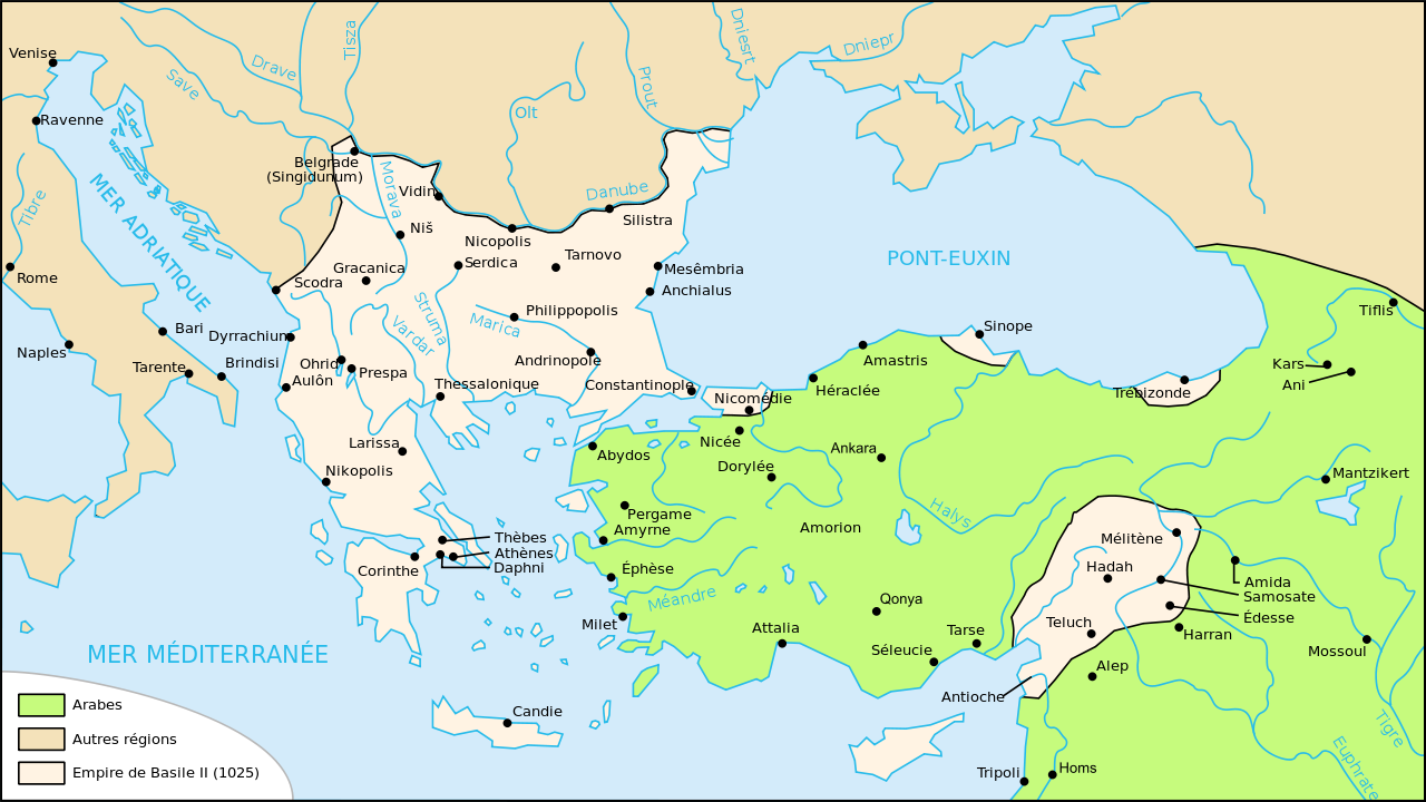
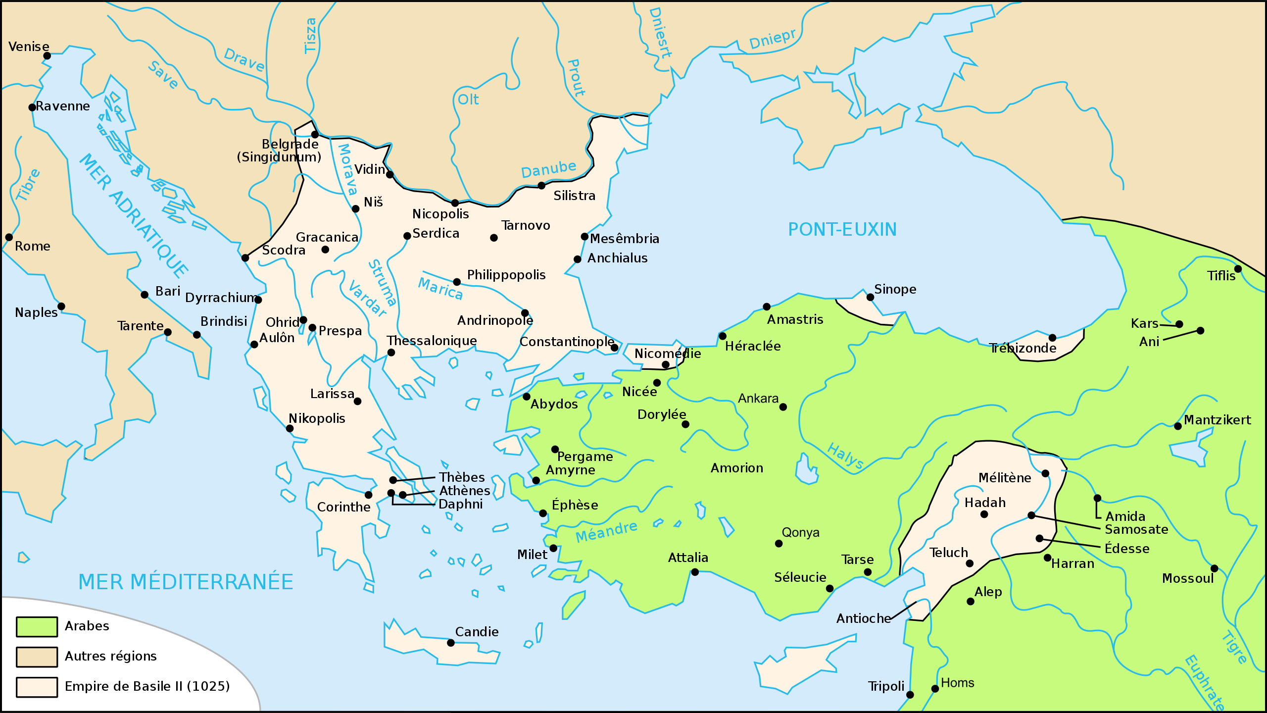
This is a map showing the Byzantine Empire in 1076.

Summary
edit| Description |
Français : Carte de l'empire byzantin en 1076 |
| Date | |
| Source | Own work based on: Map Byzantine Empire 1025-fr.svg |
| Author | Odejea |
| Other versions |
[]
|


Licensing
edit
I, the copyright holder of this work, hereby publish it under the following licenses:

|
Permission is granted to copy, distribute and/or modify this document under the terms of the GNU Free Documentation License, Version 1.2 or any later version published by the Free Software Foundation; with no Invariant Sections, no Front-Cover Texts, and no Back-Cover Texts. A copy of the license is included in the section entitled GNU Free Documentation License. |
This file is licensed under the Creative Commons Attribution-Share Alike 3.0 Unported, 2.5 Generic, 2.0 Generic and 1.0 Generic license.
- You are free:
- to share – to copy, distribute and transmit the work
- to remix – to adapt the work
- Under the following conditions:
- attribution – You must give appropriate credit, provide a link to the license, and indicate if changes were made. You may do so in any reasonable manner, but not in any way that suggests the licensor endorses you or your use.
- share alike – If you remix, transform, or build upon the material, you must distribute your contributions under the same or compatible license as the original.
You may select the license of your choice.
File history
Click on a date/time to view the file as it appeared at that time.
| Date/Time | Thumbnail | Dimensions | User | Comment | |
|---|---|---|---|---|---|
| current | 20:41, 30 April 2012 | | 1,963 × 1,104 (92 KB) | Spiridon Ion Cepleanu (talk | contribs) | Reverted to version as of 20:55, 12 November 2008 |
| 20:40, 30 April 2012 |  | 842 × 595 (122 KB) | Spiridon Ion Cepleanu (talk | contribs) | Rectification since all historic atlases and also John Haldon : ''Warfare, State And Society In The Byzantine World 565-1204'' (Routledge 1999) ISBN 1-85728-494-1, Maps IV et follow., & Piers Paul Read, "The Templars", London, Phoenix Press, Orion Publ... | |
| 20:55, 12 November 2008 |  | 1,963 × 1,104 (92 KB) | Odejea (talk | contribs) | oups mauvaise version | |
| 20:54, 12 November 2008 |  | 1,963 × 1,104 (93 KB) | Odejea (talk | contribs) | décalage vert | |
| 20:08, 12 November 2008 |  | 1,963 × 1,104 (93 KB) | Odejea (talk | contribs) | contour des domaines de Philaretos Brakhamios | |
| 20:00, 12 November 2008 |  | 1,963 × 1,104 (86 KB) | Odejea (talk | contribs) | {{Information |Description={{fr|1=Carte de l'empire byzantin en 1076}} |Source=travail personnel à partir de Image:Map Byzantine Empire 1025-fr.svg |Author=Odejea |Date=12 novembre 2008 |Permission= |other_versions= }} <!--{{ImageUp |
You cannot overwrite this file.
File usage on Commons
The following 9 pages use this file:
- File:Bizánc 1076-ban.jpg
- File:Map Byzantine Empire 1076-es.svg
- File:Map Byzantine Empire 1076-fr.jpg
- File:Map Byzantine Empire 1076-fr.svg
- File:Map Byzantine Empire 1076-pt.svg
- File:Map Byzantine Empire 1076-vi.svg
- File:Map Byzantine Empire 1076-zh.svg
- File:Map States Philaretos Brakhamios-fr.svg
- Template:Other versions/Byzantine Empire 1076
File usage on other wikis
The following other wikis use this file:
- Usage on et.wikipedia.org
- Usage on pl.wikipedia.org
- Usage on ru.wikipedia.org
- Usage on uk.wikipedia.org