File:Map Coundon 1814.jpg

Size of this preview: 800 × 344 pixels. Other resolutions: 320 × 138 pixels | 640 × 276 pixels | 1,024 × 441 pixels | 2,000 × 861 pixels.
Original file (2,000 × 861 pixels, file size: 178 KB, MIME type: image/jpeg)
Captions
Captions
Add a one-line explanation of what this file represents
Summary
edit
| Description |
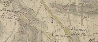
English: Map of Coundon near Coventry in 1814 |
| Date | |
| Source | Map of Coventry 1814 http://www.bl.uk/onlinegallery/onlineex/ordsurvdraw/b/002osd000000024u00216000.html |
| Author | Unknown author |
Licensing
edit
|
This work is in the public domain in its country of origin and other countries and areas where the copyright term is the author's life plus 70 years or fewer. This work is in the public domain in the United States because it was published (or registered with the U.S. Copyright Office) before January 1, 1929. | |
| This file has been identified as being free of known restrictions under copyright law, including all related and neighboring rights. | |
File history
Click on a date/time to view the file as it appeared at that time.
| Date/Time | Thumbnail | Dimensions | User | Comment | |
|---|---|---|---|---|---|
| current | 01:16, 18 June 2020 | | 2,000 × 861 (178 KB) | Maypm (talk | contribs) | {{Information |description ={{en|1=Map of Coundon near Coventry in 1814}} |date =1814 |source =Map of Coventry 1814 http://www.bl.uk/onlinegallery/onlineex/ordsurvdraw/b/002osd000000024u00216000.html |author =unknown }} Category:Coundon, Coventry |
You cannot overwrite this file.
File usage on Commons
There are no pages that use this file.
File usage on other wikis
The following other wikis use this file:
- Usage on en.wikipedia.org