File:Map Early industrialization 1992 - Touring Club Italiano CART-TEM-073.jpg
Size of this preview: 800 × 555 pixels. Other resolutions: 320 × 222 pixels | 640 × 444 pixels | 1,024 × 710 pixels | 1,280 × 888 pixels | 2,560 × 1,775 pixels | 5,000 × 3,467 pixels.
Original file (5,000 × 3,467 pixels, file size: 9.7 MB, MIME type: image/jpeg)
Captions
Captions
Add a one-line explanation of what this file represents
Summary edit
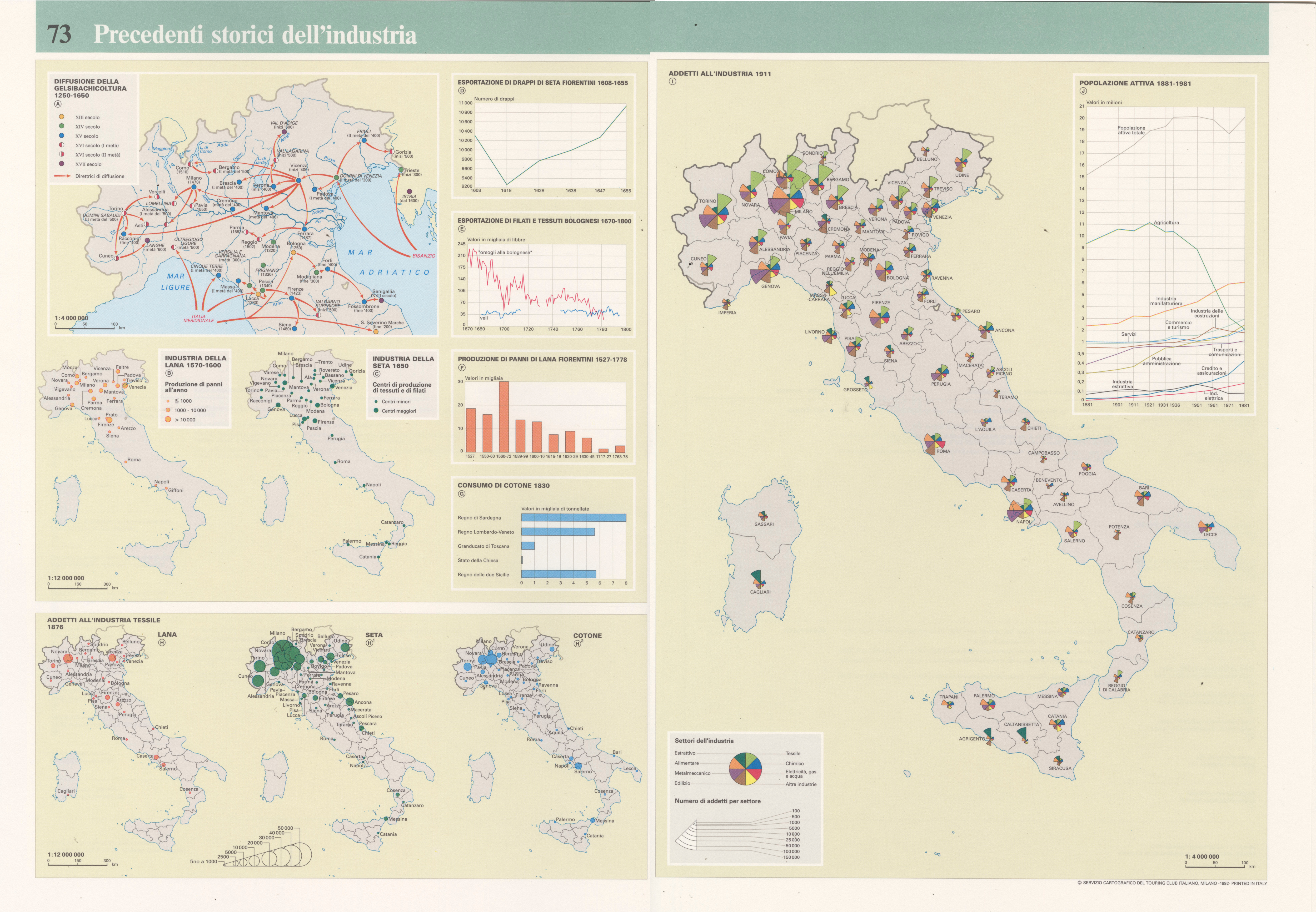
| Title |
Early industrialization |
|
| Description |
English: The table focuses on the early industrialization of Italy, distinguishing between the late-medieval period which ended in 1600 and the second one, which occured in the XX° century. More specifically: A) Diffusion of silkworm breeding and production 1250-1650. Scale: 1: 4 000 000; B) Wool industry 1570-1600. Scale: 1: 12 000 000; C) Silk industry 1650. Scale: 1: 12 000 000; D)Export of florentine silk 1608-1655; E) Export of bolognese fabric and yarn 1670-1800; F) Florentile woolen cloth production 1527-1778; G) Cotton consumption 1830; H) Textile industry employment 1876/wool. Scale: 1: 12 000 000; H1) Textile industry employment 1876 /silk. Scale: 1: 12 000 000; H2) Textile industry employment 1876/cotton. Scale: 1: 12 000 000; I) Industrial employment 1911. Scale: 1: 4 000 000; J) Employed population 1881-1981. The table is part of the Tematic Atlas realized by the TCI Cartographic Office with CNR - Italian National Research Council (1989-1992). Italiano: La tavola è dedicata ai precedenti storici dell'industria italiana, distinguendi fra il periodo tardo-medievale che ebbe fine poi nel Seicento e il periodo novecenteso. Più in dettaglio: A) Diffusione della gelsibachicoltura 1250-1650. Scala: 1: 4 000 000; B) Industria della lana 1570-1600. Scala: 1: 12 000 000; C) Industria della seta 1650. Scala: 1: 12 000 000; D) Esportazione di drappi da seta fiorentini 1608-1655; E) Esportazione di filati e tessuti bolognesi 1670-1800; F) Produzione di panni di lana fiorentini 1527-1778; G) Consumo di cotone 1830; H) Addetti all'industria testtilr 1876/lana. Scala: 1: 12 000 000; H1) Addetti all'industria tessile 1876/seta. Scala: 1: 12 000 000; H2) Addetti all'industria tessile 1876/cotone. Scala: 1: 12 000 000; I) Addetti all'industria 1911. Scala: 1: 4 000 000; J) Popolazione attiva 1881-1981. La tavola fa parte dell'Atlante Tematico realizzato dall'Ufficio Cartografico del TCI con il CNR - Consiglio Nazionale delle Ricerche (1989-1992). |
|
| Date | ||
| Source | Scan from the original work Archivio Storico del Touring Club Italiano | |
| Creator |
TCI Cartographic Office |
|
| Permission (Reusing this file) |
|
|
| Geotemporal data | ||
| Map location | Italy | |
| Map type | Economic maps | |
| Scale | 1: 4 000 000; 1: 12 000 000 | |
| Georeferencing | If inappropriate please set warp_status = skip to hide. | |
| Bibliographic data | ||
| Part of the series | Thematic Atlas of Italy | |
| Language | Italian | |
| Place of publication | Milan | |
| Publisher |
TCI |
|
| Printed by |
TCI |
|
| Archival data | ||
| Collection | ||
| Accession number |
CART.TEM.073 |
|
| Other versions | ||


Licensing edit
File history
Click on a date/time to view the file as it appeared at that time.
| Date/Time | Thumbnail | Dimensions | User | Comment | |
|---|---|---|---|---|---|
| current | 13:59, 9 November 2022 | | 5,000 × 3,467 (9.7 MB) | Ilaria Parma (TCI) (talk | contribs) | pattypan 22.03 |
You cannot overwrite this file.
File usage on Commons
The following 13 pages use this file:
- User:Magog the Ogre/Multilingual legend/2022 November 1-10
- File:Addetti industria 1911 e popolazione attiva Italia 1881-1981 - Map Early industrialization 1992 - Touring Club Italiano CART-TEM-073.jpg
- File:Addetti industria tessile Italia 1876 Lana seta cotone - Map Early industrialization 1992 - Touring Club Italiano CART-TEM-073.jpg
- File:Consumo cotone 1830 Italia - Map Early industrialization 1992 - Touring Club Italiano CART-TEM-073.jpg
- File:Diagrams D-F textiles Italy - Map Early industrialization 1992 - Touring Club Italiano CART-TEM-073.jpg
- File:Diagrams D-G textile Italy - Map Early industrialization 1992 - Touring Club Italiano CART-TEM-073.jpg
- File:Esportazione drappi seta fiorentini 1608-1655 - Map Early industrialization 1992 - Touring Club Italiano CART-TEM-073.jpg
- File:Gelsibachicoltura Nord Italia 1250-1650 - Map Early industrialization 1992 - Touring Club Italiano CART-TEM-073.jpg
- File:Industria lana 1570-1600 Italia - Map Early industrialization 1992 - Touring Club Italiano CART-TEM-073.jpg
- File:Industria lana 1570-1600 seta 1650 Italia - Map Early industrialization 1992 - Touring Club Italiano CART-TEM-073.jpg
- File:Industria seta 1650 Italia - Map Early industrialization 1992 - Touring Club Italiano CART-TEM-073.jpg
- File:Panni lana fiorentini 1527-1778 - Map Early industrialization 1992 - Touring Club Italiano CART-TEM-073.jpg
- File:Popolazione attiva Italia 1881-1981 - Map Early industrialization 1992 - Touring Club Italiano CART-TEM-073.jpg