File:Map Iof srael after 1967.GIF
No higher resolution available.
Map_Iof_srael_after_1967.GIF (357 × 370 pixels, file size: 8 KB, MIME type: image/gif)
Captions
Captions
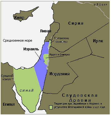
Map of Israel and territories occupied after the Six-Day War, captioned in Russian.

|
This map image could be re-created using vector graphics as an SVG file. This has several advantages; see Commons:Media for cleanup for more information. If an SVG form of this image is available, please upload it and afterwards replace this template with
{{vector version available|new image name}}.
It is recommended to name the SVG file “Map Iof srael after 1967.svg”—then the template Vector version available (or Vva) does not need the new image name parameter. |
Summary
edit
| Description |
English: Territory attached to Israel as a result of the Six Day War of 1967
Русский: Территории присоединённые к Израилю в результате Шестидневной войны 1967 года |
| Date | 01.05.09 |
| Source | Собственноручное изображение |
| Author | Umclidet |
Licensing
edit
| I, the copyright holder of this work, release this work into the public domain. This applies worldwide. In some countries this may not be legally possible; if so: I grant anyone the right to use this work for any purpose, without any conditions, unless such conditions are required by law. |
File history
Click on a date/time to view the file as it appeared at that time.
| Date/Time | Thumbnail | Dimensions | User | Comment | |
|---|---|---|---|---|---|
| current | 11:11, 1 May 2009 | | 357 × 370 (8 KB) | Umclidet (talk | contribs) | {{Information |Description={{en|1=Territory attached to Israel as a result of the Six Day War of 1967}} {{ru|1=Территории присоединённые к Израилю в результате Шестидневной войны 1967 года}} |
You cannot overwrite this file.
File usage on Commons
There are no pages that use this file.
File usage on other wikis
The following other wikis use this file:
- Usage on ca.wikipedia.org
- Usage on hy.wikipedia.org
- Usage on ru.wikipedia.org
- Usage on uk.wikipedia.org
- Usage on www.wikidata.org