File:Map Karte Carte Canhabaque.png
Size of this preview: 508 × 599 pixels. Other resolutions: 203 × 240 pixels | 407 × 480 pixels | 651 × 768 pixels | 1,200 × 1,416 pixels.
Original file (1,200 × 1,416 pixels, file size: 300 KB, MIME type: image/png)
Captions
Captions
Add a one-line explanation of what this file represents
Summary
edit
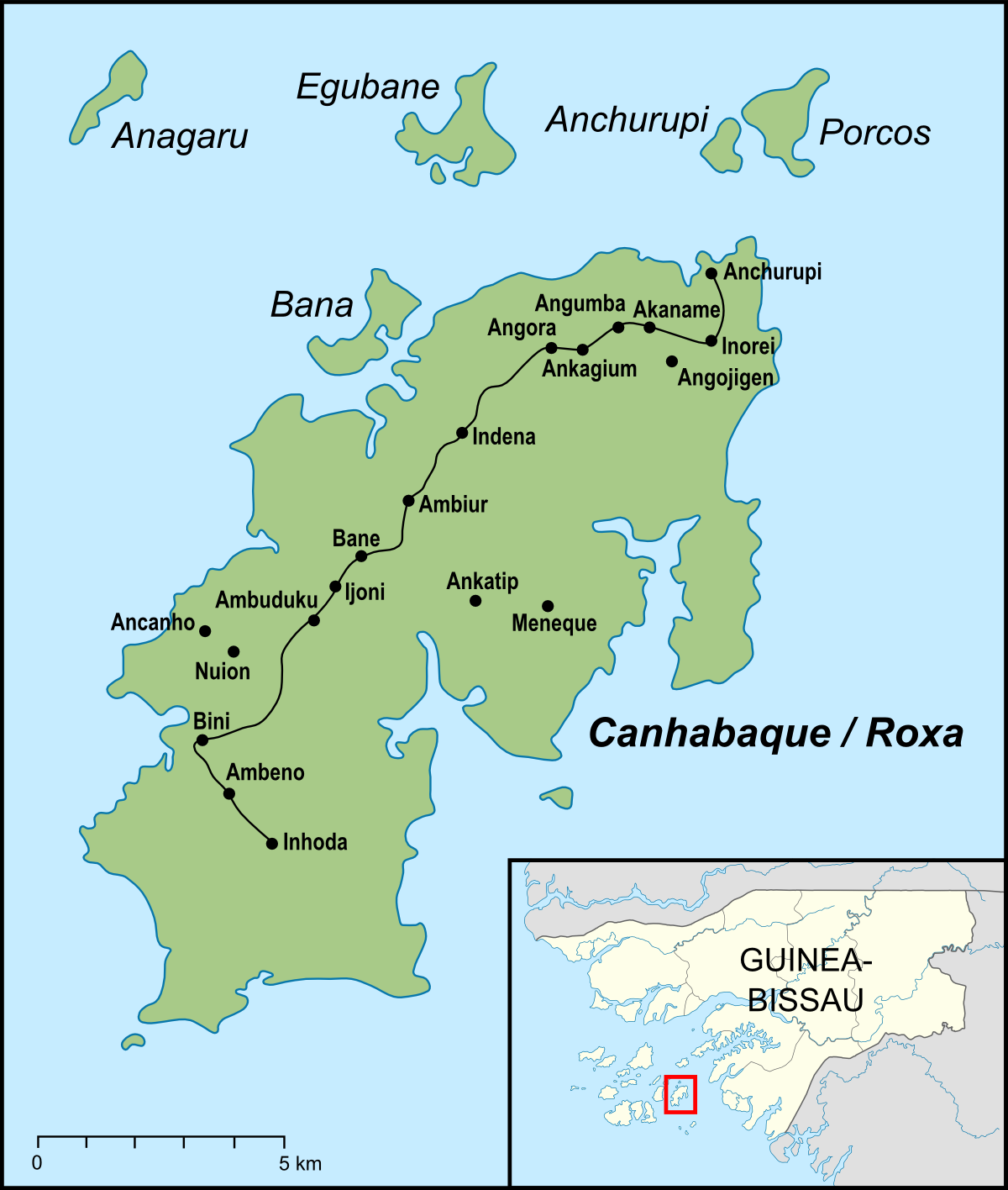
| Description | Karte der Insel Canhabaque, auch Roxa genannt. Sie liegt im Osten des Bissagos-Archipels, der zu Guinea-Bissau gehört. |
| Date | |
| Source |
"own work", used:
|
| Author | Lencer |

|
This map has been made or improved in the German Kartenwerkstatt (Map Lab). You can propose maps to improve as well.
|
Licensing
edit
This file is licensed under the Creative Commons Attribution-Share Alike 3.0 Unported license.
- You are free:
- to share – to copy, distribute and transmit the work
- to remix – to adapt the work
- Under the following conditions:
- attribution – You must give appropriate credit, provide a link to the license, and indicate if changes were made. You may do so in any reasonable manner, but not in any way that suggests the licensor endorses you or your use.
- share alike – If you remix, transform, or build upon the material, you must distribute your contributions under the same or compatible license as the original.
File history
Click on a date/time to view the file as it appeared at that time.
| Date/Time | Thumbnail | Dimensions | User | Comment | |
|---|---|---|---|---|---|
| current | 05:52, 25 October 2010 | | 1,200 × 1,416 (300 KB) | Lencer (talk | contribs) | fixes |
| 11:46, 22 October 2010 |  | 1,200 × 1,416 (292 KB) | Lencer (talk | contribs) | {{Information |Description= Karte von Canhabaque |Source="own work", used: * Bissagos 250 txu-oclc-6595921-nc28-2.jpg by Army Map Service, Corps of Engineers, U.S. Army * [http://books. |
You cannot overwrite this file.
File usage on Commons
There are no pages that use this file.
File usage on other wikis
The following other wikis use this file:
- Usage on de.wikipedia.org
- Usage on en.wikipedia.org
- Usage on es.wikipedia.org
- Usage on hr.wikipedia.org
- Usage on lt.wikipedia.org
- Usage on pt.wikipedia.org