File:Map Kashmir Standoff 2003.png

Size of this preview: 760 × 600 pixels. Other resolutions: 304 × 240 pixels | 608 × 480 pixels | 869 × 686 pixels.
Original file (869 × 686 pixels, file size: 53 KB, MIME type: image/png)
Captions
Captions
Add a one-line explanation of what this file represents
Summary edit
| Description |
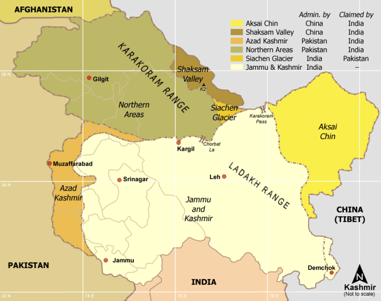
Kashmir region - Political and Military standoff between India, China and Pakistan Self-made from Reference: Atlas of the World (2003 Comprehensive Ed.) - The w:Royal Geographical Society - (ISBN 0540084050) |
| Date | 3 January 2006 (original upload date) |
| Source | No machine-readable source provided. Own work assumed (based on copyright claims). |
| Author | No machine-readable author provided. Miljoshi assumed (based on copyright claims). |
Licensing edit
I, the copyright holder of this work, hereby publish it under the following licenses:

|
Permission is granted to copy, distribute and/or modify this document under the terms of the GNU Free Documentation License, Version 1.2 or any later version published by the Free Software Foundation; with no Invariant Sections, no Front-Cover Texts, and no Back-Cover Texts. A copy of the license is included in the section entitled GNU Free Documentation License. |
| This file is licensed under the Creative Commons Attribution-Share Alike 3.0 Unported license. | ||
| ||
| This licensing tag was added to this file as part of the GFDL licensing update. |
This file is licensed under the Creative Commons Attribution-Share Alike 2.5 Generic, 2.0 Generic and 1.0 Generic license.
- You are free:
- to share – to copy, distribute and transmit the work
- to remix – to adapt the work
- Under the following conditions:
- attribution – You must give appropriate credit, provide a link to the license, and indicate if changes were made. You may do so in any reasonable manner, but not in any way that suggests the licensor endorses you or your use.
- share alike – If you remix, transform, or build upon the material, you must distribute your contributions under the same or compatible license as the original.
You may select the license of your choice.
derivative works edit
Derivative works of this file: Map Kashmir Standoff 2003 mr.png
File history
Click on a date/time to view the file as it appeared at that time.
| Date/Time | Thumbnail | Dimensions | User | Comment | |
|---|---|---|---|---|---|
| current | 17:58, 29 July 2017 | | 869 × 686 (53 KB) | फ़िलप्रो (talk | contribs) | Demchok is administered by India |
| 22:28, 6 June 2010 |  | 869 × 686 (44 KB) | Ras67 (talk | contribs) | cropped | |
| 17:36, 3 January 2006 |  | 885 × 703 (58 KB) | Miljoshi (talk | contribs) | Kashmir region - Political and Military standoff between India, China and Pakistan Reference: Atlas of the World (2003 Comprehensive Ed.) - The w:Royal Geographic Society - w:ISBN 0540084050 - Self-made. |
You cannot overwrite this file.
File usage on Commons
The following page uses this file:
File usage on other wikis
The following other wikis use this file:
- Usage on an.wikipedia.org
- Usage on de.wikipedia.org
- Usage on en.wikipedia.org
- Usage on fr.wikipedia.org
- Usage on hi.wikipedia.org
- Usage on ja.wikipedia.org
- Usage on no.wikipedia.org
- Usage on pl.wikipedia.org
- Usage on pnb.wikipedia.org
- Usage on ta.wiktionary.org