File:Map Languages CH.png

Size of this preview: 800 × 483 pixels. Other resolutions: 320 × 193 pixels | 640 × 386 pixels | 1,024 × 618 pixels | 1,500 × 905 pixels.
Original file (1,500 × 905 pixels, file size: 163 KB, MIME type: image/png)
Captions
Captions
Add a one-line explanation of what this file represents
Summary
edit| Description |
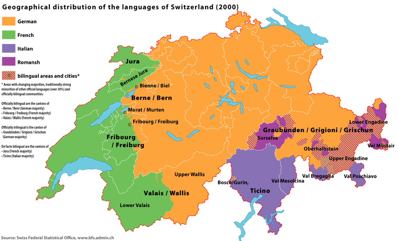
English: Map of the geographical distribution of the official languages of Switzerland (2000) |
| Date | |
| Source | Swiss Federal Statistical Office; census of 2000 |
| Author | Marco Zanoli (sidonius 13:20, 18 June 2006 (UTC)) |
| Other versions |
|


|
File:Sprachen CH 2000 EN.svg is a vector version of this file. It should be used in place of this PNG file when not inferior.
File:Map Languages CH.png → File:Sprachen CH 2000 EN.svg
For more information, see Help:SVG. |
 |
Licensing
edit
You may use my work outside wikipedia for free as long as you name me as the author. If you would like to use my work in a print medium, please send me a specimen copy.
Contact me if you have questions regarding the license or if you want individual changes to the map (marco.zanoli at hotmail.ch). This file is licensed under the Creative Commons Attribution-Share Alike 4.0 International license. Attribution: Marco Zanoli
|
File history
Click on a date/time to view the file as it appeared at that time.
| Date/Time | Thumbnail | Dimensions | User | Comment | |
|---|---|---|---|---|---|
| current | 04:58, 4 July 2010 | | 1,500 × 905 (163 KB) | DcoetzeeBot (talk | contribs) | Remove watermark, add author and license data to image metadata, decrease filesize with pngcrush |
| 13:57, 21 January 2007 |  | 1,500 × 905 (162 KB) | Sidonius (talk | contribs) | better colours, no frame | |
| 20:24, 4 January 2007 |  | 1,500 × 905 (162 KB) | Sidonius (talk | contribs) | versuch Vorschaubild anzupassen | |
| 11:29, 4 January 2007 |  | 1,500 × 905 (162 KB) | Sidonius (talk | contribs) | colours adjusted, small corrections | |
| 13:20, 18 June 2006 |  | 1,500 × 957 (278 KB) | Sidonius (talk | contribs) | {{Information| |Description=Map of the geographical distribution of the official languages of Switzerland (2000) |Source=Swiss Federal Statistical Office |Date=18.6.2006 |Author=Marco Zanoli (~~~~) |Permission=cc-by-sa-2.5; please notify author if you wan |
You cannot overwrite this file.
File usage on Commons
The following 8 pages use this file:
File usage on other wikis
The following other wikis use this file:
- Usage on ar.wikipedia.org
- Usage on az.wikipedia.org
- Usage on bg.wikipedia.org
- Usage on bn.wikipedia.org
- Usage on bs.wikipedia.org
- Usage on cs.wikipedia.org
- Usage on cv.wikipedia.org
- Usage on cy.wikipedia.org
- Usage on da.wikipedia.org
- Usage on de.wikipedia.org
- Usage on el.wiktionary.org
- Usage on en.wikipedia.org
- Usage on en.wikivoyage.org
- Usage on eo.wikipedia.org
- Usage on es.wikipedia.org
- Usage on eu.wikipedia.org
- Usage on fa.wikipedia.org
- Usage on fy.wikipedia.org
- Usage on he.wikipedia.org
- Usage on hr.wikipedia.org
- Usage on hu.wikipedia.org
- Usage on hy.wikipedia.org
- Usage on id.wikipedia.org
- Usage on ja.wikipedia.org
- Usage on lb.wikipedia.org
- Usage on lt.wikipedia.org
- Usage on mt.wikipedia.org
- Usage on nds-nl.wikipedia.org
- Usage on nl.wikipedia.org
View more global usage of this file.