File:Map Qingdao–Yancheng railway.png
No higher resolution available.
Map_Qingdao–Yancheng_railway.png (369 × 533 pixels, file size: 179 KB, MIME type: image/png)
Captions
Captions
Add a one-line explanation of what this file represents
Summary edit
| Description |
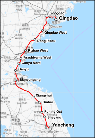
English: Map of the Qingdao–Yancheng railway |
|||||||||
| Date | ||||||||||
| Source |
Own work Map was created using:
|
|||||||||
| Creator |
|
|||||||||
| Permission (Reusing this file) |
|
|||||||||
| Geotemporal data | ||||||||||
| Bounding box |
|
|||||||||
| Georeferencing | ||||||||||
This file is licensed under the Creative Commons Attribution-Share Alike 2.0 Generic license.
- You are free:
- to share – to copy, distribute and transmit the work
- to remix – to adapt the work
- Under the following conditions:
- attribution – You must give appropriate credit, provide a link to the license, and indicate if changes were made. You may do so in any reasonable manner, but not in any way that suggests the licensor endorses you or your use.
- share alike – If you remix, transform, or build upon the material, you must distribute your contributions under the same or compatible license as the original.
| This work is licensed under the Open Database License (summary). |
File history
Click on a date/time to view the file as it appeared at that time.
| Date/Time | Thumbnail | Dimensions | User | Comment | |
|---|---|---|---|---|---|
| current | 03:40, 12 March 2022 | | 369 × 533 (179 KB) | Pechristener (talk | contribs) | Ganyu Nord fehlte |
| 22:10, 11 March 2022 |  | 369 × 533 (177 KB) | Pechristener (talk | contribs) | {{Map |Description={{en|Map of the Qingdao–Yancheng railway}} |Source= {{own}} Map was created using: *[http://www.openstreetmap.org/ Open Street Map] *[http://www.thunderforest.com/ Thunderforest map tiles] as background |Date=2022-03-11 |Author= * OSM data: Open Street Map contributors * Thunderforest map tiles: Andy Allan * Rendering: {{u|Pechriste}} |Permission= * Map data (c) OpenStreetMap (and) contributors, CC-BY-SA * Thunderforest map tiles, CC-BY-SA 2.0 |other_versions= }} {{cc-b... |
You cannot overwrite this file.
File usage on Commons
There are no pages that use this file.
File usage on other wikis
The following other wikis use this file:
- Usage on de.wikipedia.org