File:Map Siberian route uk.svg

Size of this PNG preview of this SVG file: 800 × 400 pixels. Other resolutions: 320 × 160 pixels | 640 × 320 pixels | 1,024 × 512 pixels | 1,280 × 640 pixels | 2,560 × 1,280 pixels | 1,000 × 500 pixels.
Original file (SVG file, nominally 1,000 × 500 pixels, file size: 2.62 MB)
Captions
Captions
Add a one-line explanation of what this file represents
| Description |
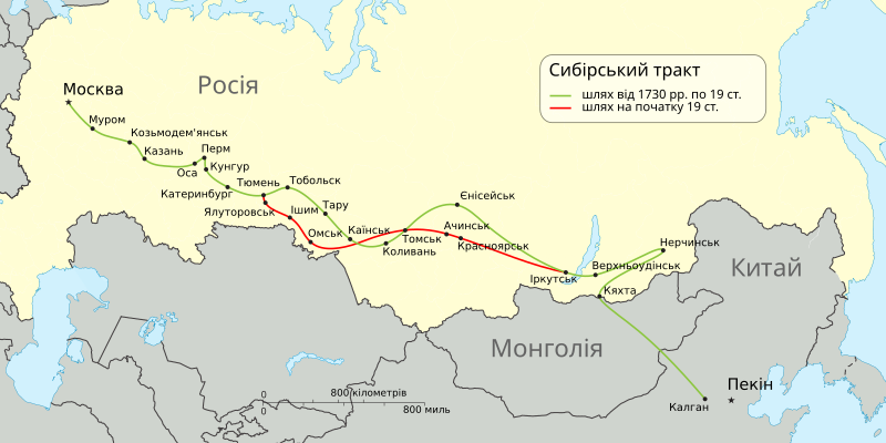
English: Siberian route schematic map. Русский: Схематическая карта прохождения Сибирского тракта. Українська: Схематична карта проходження Сибірського тракту. |
| Date | (UTC) |
| Source | |
| Author |
|
| This is a retouched picture, which means that it has been digitally altered from its original version. Modifications: Ukrainian translation. The original can be viewed here: Map Siberian route.svg:
|
I, the copyright holder of this work, hereby publish it under the following license:
| I, the copyright holder of this work, release this work into the public domain. This applies worldwide. In some countries this may not be legally possible; if so: I grant anyone the right to use this work for any purpose, without any conditions, unless such conditions are required by law. |
Original upload log
edit
This image is a derivative work of the following images:
- File:Map_Siberian_route.svg licensed with PD-self
- 2009-04-21T23:31:14Z Ahnode 1000x500 (2279998 Bytes) {{Information |Description={{en|1=[[w:Siberian route|Siberian route]] schematic map. }} {{ru|1=Схематическая карта прохождения [[:ru:Сибирский тракт|Сибирского тракта
Uploaded with derivativeFX
File history
Click on a date/time to view the file as it appeared at that time.
| Date/Time | Thumbnail | Dimensions | User | Comment | |
|---|---|---|---|---|---|
| current | 16:39, 8 September 2009 | | 1,000 × 500 (2.62 MB) | AS (talk | contribs) | {{Information |Description={{en|1=Siberian route schematic map. }} {{ru|1=Схематическая карта прохождения Сибирского тракта.}} {{uk|1=Схематич� |
You cannot overwrite this file.
File usage on Commons
There are no pages that use this file.
File usage on other wikis
The following other wikis use this file:
- Usage on uk.wikipedia.org