File:Map TH provinces by geographic.png
Size of this preview: 400 × 600 pixels. Other resolutions: 160 × 240 pixels | 320 × 480 pixels.
Original file (800 × 1,200 pixels, file size: 98 KB, MIME type: image/png)
Captions
Captions
Add a one-line explanation of what this file represents
Summary
edit
| Description | |
| Date | 26 June 2008 (original upload date) |
| Source | Transferred from th.wikipedia to Commons by 2T using CommonsHelper. |
| Author | Thanyakij at Thai Wikipedia |
Licensing
edit
| This work has been released into the public domain by its author, Thanyakij at Thai Wikipedia. This applies worldwide. In some countries this may not be legally possible; if so: Thanyakij grants anyone the right to use this work for any purpose, without any conditions, unless such conditions are required by law. |
Original upload log
edit
The original description page was here. All following user names refer to th.wikipedia.
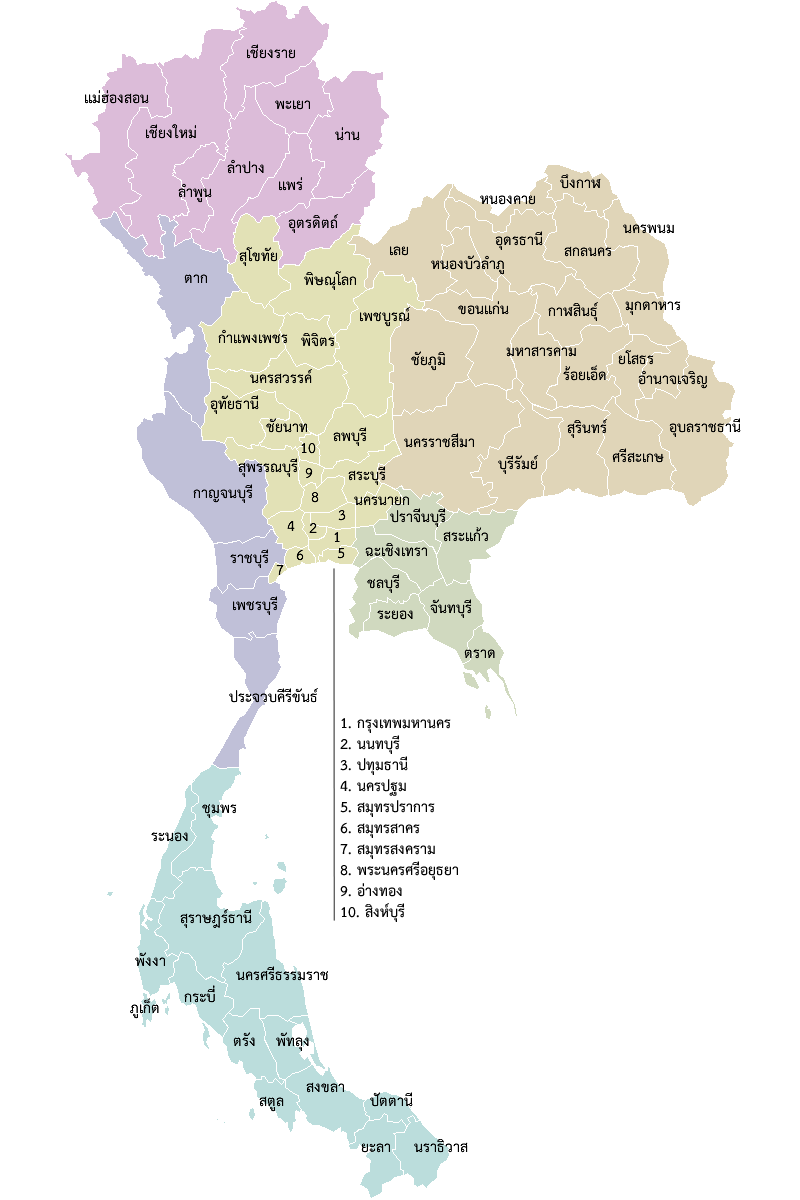
- 2008-06-26 21:28 Thanyakij 800×1200× (39667 bytes) == คำอธิบายโดยย่อ == {{กล่องข้อมูล ภาพเสรี | คำอธิบายภาพ = แผนที่ประเทศไทย แสดงการแบ่งจังหวัดตาม�
File history
Click on a date/time to view the file as it appeared at that time.
| Date/Time | Thumbnail | Dimensions | User | Comment | |
|---|---|---|---|---|---|
| current | 15:04, 23 March 2011 | | 800 × 1,200 (98 KB) | Aquapatinth (talk | contribs) | Added: Büŋkāḷ Province (Bueng Kan Province) |
| 15:03, 23 March 2011 |  | 800 × 1,200 (39 KB) | Aquapatinth (talk | contribs) | Added: Büŋkāḷ Province (Bueng Kan Province) | |
| 02:13, 4 November 2010 |  | 800 × 1,200 (39 KB) | File Upload Bot (Magnus Manske) (talk | contribs) | {{BotMoveToCommons|th.wikipedia|year={{subst:CURRENTYEAR}}|month={{subst:CURRENTMONTHNAME}}|day={{subst:CURRENTDAY}}}} {{Information |Description={{th|th:หมวดหมู่:แผนที่ประเทศไทย}} |Source=Transferred f |
You cannot overwrite this file.
File usage on Commons
There are no pages that use this file.
File usage on other wikis
The following other wikis use this file:
- Usage on incubator.wikimedia.org
- Usage on lo.wikipedia.org
- Usage on ms.wikipedia.org
- Thailand
- Bangkok
- Wilayah Narathiwat
- Wilayah Yala
- Templat:Wilayah Thai
- Wilayah Pattani
- Wilayah Satun
- Chumphon
- Wilayah Krabi
- Nakhon Si Thammarat
- Phang Nga
- Phattalung
- Phuket
- Ranong
- Wilayah Songkhla
- Surat Thani
- Wilayah Trang
- Chachoengsao
- Chanthaburi
- Chonburi
- Chiang Mai (wilayah)
- Chiang Rai
- Kamphaeng Phet
- Lampang
- Lamphun
- Mae Hong Son
- Nakhon Sawan
- Nan (wilayah)
- Phayao
- Phetchabun
- Phichit
- Uttaradit
- Wilayah Uthai Thani
- Tak
- Phitsanulok
- Phrae
- Sukhothai
- Amnat Charoen
- Buriram
- Chaiyaphum
- Kanchanaburi
- Rayong
- Prachinburi
- Sa Kaeo
- Trat
- Kalasin
View more global usage of this file.