File:Map of Agocho, Shima.png
Size of this preview: 557 × 600 pixels. Other resolutions: 223 × 240 pixels | 558 × 601 pixels.
Original file (558 × 601 pixels, file size: 97 KB, MIME type: image/png)
Captions
Captions
Add a one-line explanation of what this file represents
Summary
edit
| Description |
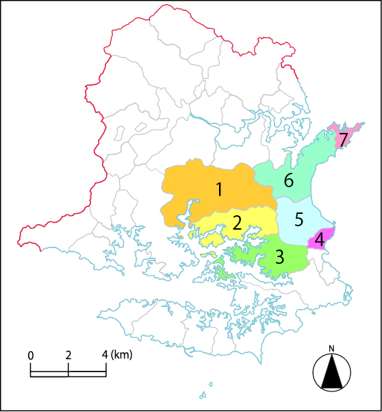
English: This is the map of Agocho, Shima, Mie, Japan. In this map, 1 is Ugata, 2 is Shimmei, 3 is Tategami, 4 is Shijima, 5 is Koka, 6 is Ko, 7 is Anori. 日本語: 三重県志摩市阿児町の位置図。1は鵜方、2は神明、3は立神、4は志島、5は甲賀、6は国府、7は安乗である。この数字は志摩市阿児町の郵便番号〒517-050XのXと対応する。 |
| Date | |
| Source | Own work |
| Author | Miyuki Meinaka |
Licensing
edit
I, the copyright holder of this work, hereby publish it under the following license:
This file is licensed under the Creative Commons Attribution-Share Alike 3.0 Unported license.
- You are free:
- to share – to copy, distribute and transmit the work
- to remix – to adapt the work
- Under the following conditions:
- attribution – You must give appropriate credit, provide a link to the license, and indicate if changes were made. You may do so in any reasonable manner, but not in any way that suggests the licensor endorses you or your use.
- share alike – If you remix, transform, or build upon the material, you must distribute your contributions under the same or compatible license as the original.
File history
Click on a date/time to view the file as it appeared at that time.
| Date/Time | Thumbnail | Dimensions | User | Comment | |
|---|---|---|---|---|---|
| current | 06:43, 11 October 2011 | | 558 × 601 (97 KB) | Miyuki Meinaka (talk | contribs) |
You cannot overwrite this file.
File usage on Commons
There are no pages that use this file.
File usage on other wikis
The following other wikis use this file:
- Usage on ja.wikipedia.org