File:Map of Albemarle County LOC 99446507.tif
Size of this JPG preview of this TIF file: 506 × 599 pixels. Other resolutions: 203 × 240 pixels | 405 × 480 pixels | 648 × 768 pixels | 864 × 1,024 pixels | 1,729 × 2,048 pixels | 8,238 × 9,759 pixels.
Original file (8,238 × 9,759 pixels, file size: 230.01 MB, MIME type: image/tiff)
Captions
Captions
Add a one-line explanation of what this file represents
Summary edit
| Warning | The original file is very high-resolution. It might not load properly or could cause your browser to freeze when opened at full size. |
|---|
| Description |
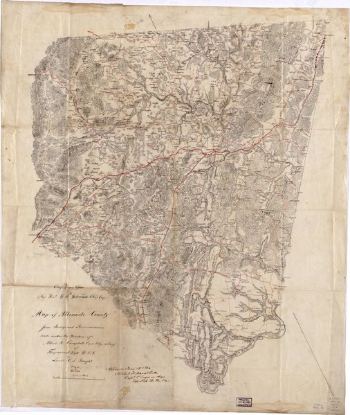
English: Shows villages, houses, names of residents, roads, and railroads. Relief shown by hachures. At head of title: Chief Engrs. Office, Maj. Genl. G. [i.e., J.] F. Gilmer Chief Engr. "Approved June 15, 1864 Albert H. Campbell Capt. P. Engrs in chge. Top. Dep. D.N. Va.". Pen-and-ink on tracing linen. LC Civil War Maps (2nd ed.), 520a.8 Available also through the Library of Congress web site as raster image. Call no. cited in LC Civil War Maps (2nd ed.): G3883.A3G46 1864. C3 Vault |
||
| Title | Map of Albemarle County | ||
| Shelf ID | G3883.A3G46 1864 .D8 | ||
| Date | |||
| Source | https://www.loc.gov/item/99446507/ | ||
| Author | Dwight, C. S. | ||
| Permission (Reusing this file) |
|
||
| Other versions |
|
||
| Location | United States · Albemarle County · Virginia | ||
| Part of | Military Battles And Campaigns · American Memory · Civil War Maps · Catalog · Geography And Map Division | ||
| Subject | United States · Albemarle County · Maps, Manuscript · Landowners · Virginia |


Licensing edit
|
This is a faithful photographic reproduction of a two-dimensional, public domain work of art. The work of art itself is in the public domain for the following reason:
The official position taken by the Wikimedia Foundation is that "faithful reproductions of two-dimensional public domain works of art are public domain".
This photographic reproduction is therefore also considered to be in the public domain in the United States. In other jurisdictions, re-use of this content may be restricted; see Reuse of PD-Art photographs for details. | ||||
File history
Click on a date/time to view the file as it appeared at that time.
| Date/Time | Thumbnail | Dimensions | User | Comment | |
|---|---|---|---|---|---|
| current | 03:25, 2 June 2018 |  | 8,238 × 9,759 (230.01 MB) | Fæ (talk | contribs) | LOC Maps https://www.loc.gov/item/99446507/ #2057 |
You cannot overwrite this file.
File usage on Commons
The following page uses this file: