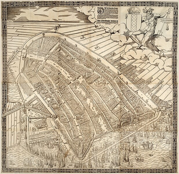
File:Map of Amsterdam, 1544 by Cornelis Anthonisz. Universiteit van Amsterdam OTM HB-KZL W.X. 015.jpg

Original file (12,401 × 12,022 pixels, file size: 183.74 MB, MIME type: image/jpeg)
Captions
Captions
Summary edit
| Cornelis Anthonisz.: Map of Amsterdam, 1544
|
|||||||||||||||||||||||||||
|---|---|---|---|---|---|---|---|---|---|---|---|---|---|---|---|---|---|---|---|---|---|---|---|---|---|---|---|
| Artist |
|
||||||||||||||||||||||||||
| Title |
Dutch: Die vermaerde Coopstadt van Amstelredam :, gheconterfeyt met alle zijn Wateren, Brugghen, Straeten, Kercken, Cloosteren, Huysen, Toornen, Poorten, ende mueren, ende omlegghende situatie, ghemaeckt ter eeren der K.M. ende oock den Eersamen Raedt der selver Stadt, ende allen Liefhebberen der Consten etc. Map of Amsterdam, 1544 title QS:P1476,nl:"Die vermaerde Coopstadt van Amstelredam :, gheconterfeyt met alle zijn Wateren, Brugghen, Straeten, Kercken, Cloosteren, Huysen, Toornen, Poorten, ende mueren, ende omlegghende situatie, ghemaeckt ter eeren der K.M. ende oock den Eersamen Raedt der selver Stadt, ende allen Liefhebberen der Consten etc.
label QS:Lnl,"Die vermaerde Coopstadt van Amstelredam :, gheconterfeyt met alle zijn Wateren, Brugghen, Straeten, Kercken, Cloosteren, Huysen, Toornen, Poorten, ende mueren, ende omlegghende situatie, ghemaeckt ter eeren der K.M. ende oock den Eersamen Raedt der selver Stadt, ende allen Liefhebberen der Consten etc.
label QS:Len,"Map of Amsterdam, 1544"
label QS:Lde,"Stadtplan von Amsterdam, 1544" |
||||||||||||||||||||||||||
| Object type |
woodcut print / version, edition or translation |
||||||||||||||||||||||||||
| Date |
1544 |
||||||||||||||||||||||||||
| Publication date |
between 1544 and 1545 date QS:P,+1544-00-00T00:00:00Z/8,P1319,+1544-00-00T00:00:00Z/9,P1326,+1545-00-00T00:00:00Z/9 |
||||||||||||||||||||||||||
| Medium |
ink and paper |
||||||||||||||||||||||||||
| Collection |
institution QS:P195,Q214341
|
||||||||||||||||||||||||||
| Accession number | |||||||||||||||||||||||||||
| Notes | 2nd version 1544 | ||||||||||||||||||||||||||
| References |
https://uvaerfgoed.nl//beeldbank/xview?identifier=hdl:11245/3.2836 |
||||||||||||||||||||||||||
| Source/Photographer | https://uvaerfgoed.nl//beeldbank/xview?identifier=hdl:11245/3.2836 | ||||||||||||||||||||||||||
Licensing edit
| Public domainPublic domainfalsefalse |
|
This work is in the public domain in its country of origin and other countries and areas where the copyright term is the author's life plus 100 years or fewer. This work is in the public domain in the United States because it was published (or registered with the U.S. Copyright Office) before January 1, 1929. | |
| This file has been identified as being free of known restrictions under copyright law, including all related and neighboring rights. | |
https://creativecommons.org/publicdomain/mark/1.0/PDMCreative Commons Public Domain Mark 1.0falsefalse
File history
Click on a date/time to view the file as it appeared at that time.
| Date/Time | Thumbnail | Dimensions | User | Comment | |
|---|---|---|---|---|---|
| current | 18:20, 18 February 2023 |  | 12,401 × 12,022 (183.74 MB) | Vincent Steenberg (talk | contribs) | Uploaded a work by Cornelis Anthonisz. from https://uvaerfgoed.nl//beeldbank/xview?identifier=hdl:11245/3.2836 with UploadWizard |
You cannot overwrite this file.
File usage on Commons
The following 10 pages use this file:
- File:Cornelis Anthonisz. - vogelvluchtkaart amsterdam 1544 - Detail Dam.jpg
- File:Cornelis Anthonisz. - vogelvluchtkaart amsterdam detail 01.jpg
- File:Cornelis anthonisz vogelvluchtkaart amsterdam.JPG
- File:Lastage,wiki.jpg
- File:Map of Amsterdam, 1544 by Cornelis Anthonisz. Rijksmuseum Amsterdam KOG-2684.jpg
- File:Map of Amsterdam, 1544 by Cornelis Anthonisz. Universiteit van Amsterdam OTM HB-KZL W.X. 015.jpg
- File:Map of Amsterdam, 1544 by Cornelis Anthonisz. Universiteit van Amsterdam OTM HB-KZL W.X. 015 black and white version.jpg
- File:Map of Amsterdam, 1544 by Cornelis Anthonisz. Universiteit van Amsterdam OTM HB-KZL W.X. 015 border removed.jpg (file redirect)
- File:Map of Amsterdam, 1544 by Cornelis Anthonisz. Universiteit van Amsterdam OTM HB-KZL W.X. 015 text bloc.jpg
- Category:Map of Amsterdam, 1544
File usage on other wikis
The following other wikis use this file:
- Usage on nl.wikipedia.org
- Usage on www.wikidata.org
Metadata
This file contains additional information such as Exif metadata which may have been added by the digital camera, scanner, or software program used to create or digitize it. If the file has been modified from its original state, some details such as the timestamp may not fully reflect those of the original file. The timestamp is only as accurate as the clock in the camera, and it may be completely wrong.
| Image title |
|
|---|---|
| Width | 12,401 px |
| Height | 12,022 px |
| Bits per component |
|
| Compression scheme | Uncompressed |
| Pixel composition | RGB |
| Image data location | 9,080 |
| Orientation | Normal |
| Number of components | 3 |
| Number of rows per strip | 12,022 |
| Bytes per compressed strip | 447,254,466 |
| Horizontal resolution | 285 dpi |
| Vertical resolution | 285 dpi |
| Data arrangement | chunky format |
| Software used | Adobe Photoshop Elements 9.0 Windows |
| File change date and time | 18:48, 18 February 2023 |
| Color space | sRGB |
| Image width | 12,401 px |
| Image height | 12,022 px |
| Date and time of digitizing | 16:45, 18 February 2023 |
| Date metadata was last modified | 19:48, 18 February 2023 |
| Unique ID of original document | xmp.did:FF269010B2AFED11AB0CACDDA1ADF20F |
| IIM version | 27,751 |

