File:Map of Bedford.pdf

Size of this JPG preview of this PDF file: 768 × 600 pixels. Other resolutions: 308 × 240 pixels | 615 × 480 pixels | 984 × 768 pixels | 1,280 × 999 pixels | 1,537 × 1,200 pixels.
Original file (1,537 × 1,200 pixels, file size: 1.23 MB, MIME type: application/pdf)
Captions
Captions
Add a one-line explanation of what this file represents
Summary edit
| Description |
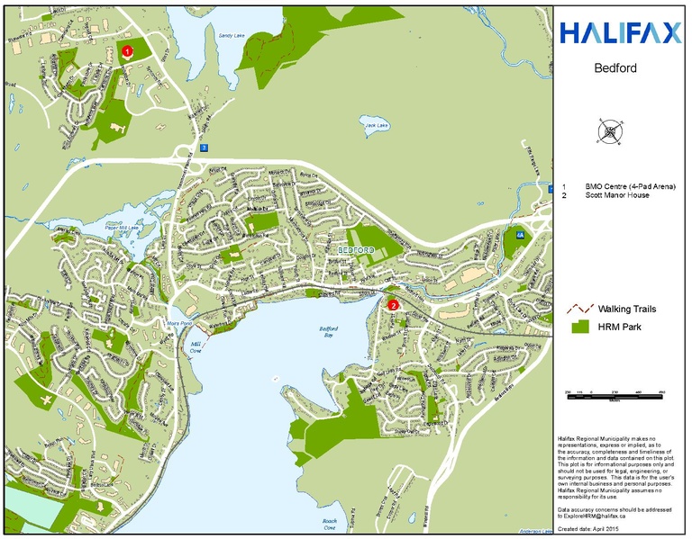
English: A map of the Bedford area of HRM. Halifax Regional Municipality makes no representations, express or implied, as to the accuracy, completeness and timeliness of the information and data contained on this plot. This plot is for informational purposes only and should not be used for legal, engineering, or surveying purposes. This data is for the user's own internal business and personal purposes. Halifax Regional Municipality assumes no responsibility for its use. |
| Date | |
| Source | http://www.halifax.ca/giss/PrintableMaps.php |
| Author | Halifax Regional Municipality GISS division publicly accessible printable maps. |
Licensing edit
| This work has been released into the public domain by its author, http://www.halifax.ca/giss/PrintableMaps.php. This applies worldwide. In some countries this may not be legally possible; if so: http://www.halifax.ca/giss/PrintableMaps.php grants anyone the right to use this work for any purpose, without any conditions, unless such conditions are required by law.
|
File history
Click on a date/time to view the file as it appeared at that time.
| Date/Time | Thumbnail | Dimensions | User | Comment | |
|---|---|---|---|---|---|
| current | 13:13, 27 December 2016 |  | 1,537 × 1,200 (1.23 MB) | WayeMason (talk | contribs) | User created page with UploadWizard |
You cannot overwrite this file.
File usage on Commons
There are no pages that use this file.
File usage on other wikis
The following other wikis use this file:
- Usage on en.wikipedia.org