File:Map of Blåmannsisen glacier.png

Size of this preview: 800 × 475 pixels. Other resolutions: 320 × 190 pixels | 640 × 380 pixels | 1,024 × 607 pixels | 1,443 × 856 pixels.
Original file (1,443 × 856 pixels, file size: 1.74 MB, MIME type: image/png)
Captions
Captions
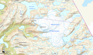
Map of Blåmannsisen glacier in Fauske and Sørfold, Nordland, Norway.
Summary
edit
| Description |
English: Blåmannisen (literally Blue man's ice) is the fifth largest glacier in Norway. The glacier is located in the municipalities of Fauske and Sørfold, approximately 2 km from the border with Sweden. The highest point of the Blåmann ice is 1,560 meters above sea level and is called Blåmannen (Blue Man). The Blåmannisen is a plateau glacier, i.e. a fairly flat, high-lying glacier surrounded by steep mountain sides. |
| Date | |
| Source | www.kartverket.no |
| Author | © Kartverket, Norge |
Licensing
edit
This file is licensed under the Creative Commons Attribution-Share Alike 4.0 International license.
- You are free:
- to share – to copy, distribute and transmit the work
- to remix – to adapt the work
- Under the following conditions:
- attribution – You must give appropriate credit, provide a link to the license, and indicate if changes were made. You may do so in any reasonable manner, but not in any way that suggests the licensor endorses you or your use.
- share alike – If you remix, transform, or build upon the material, you must distribute your contributions under the same or compatible license as the original.
File history
Click on a date/time to view the file as it appeared at that time.
| Date/Time | Thumbnail | Dimensions | User | Comment | |
|---|---|---|---|---|---|
| current | 06:44, 22 August 2023 | | 1,443 × 856 (1.74 MB) | Frankemann (talk | contribs) | Uploaded a work by © Kartverket, Norge from www.kartverket.no with UploadWizard |
You cannot overwrite this file.
File usage on Commons
There are no pages that use this file.
File usage on other wikis
The following other wikis use this file:
- Usage on no.wikipedia.org