File:Map of Burkina Faso cs.png
No higher resolution available.
Map_of_Burkina_Faso_cs.png (329 × 353 pixels, file size: 15 KB, MIME type: image/png)
Captions
Captions
Add a one-line explanation of what this file represents
Summary edit
| Description |
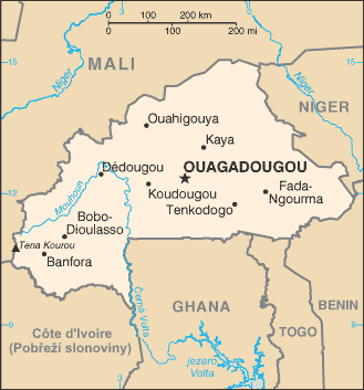
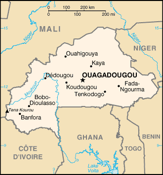
Čeština: Mapa Burkiny Faso – přeložená mapa z CIA World Factbook. English: Map of Burkina Faso, translated to Czech. |
| Source | Transferred from cs.wikipedia to Commons. From CIA WF |
| Author |
Licensing edit
This image is in the public domain because it contains materials that originally came from the United States Central Intelligence Agency's World Factbook.
|
 |
Original upload log edit
The original description page was here. All following user names refer to cs.wikipedia.
- 2006-07-06 15:35 Nádvorník 329×353×4 (15054 bytes) Mapa [[Burkina Faso]] - přeložená mapa z CIA World Factbook.
File history
Click on a date/time to view the file as it appeared at that time.
| Date/Time | Thumbnail | Dimensions | User | Comment | |
|---|---|---|---|---|---|
| current | 15:25, 2 April 2007 | | 329 × 353 (15 KB) | Timichal (talk | contribs) | {{Information |Description={{cs|Mapa Burkiny Faso – přeložená mapa z CIA World Factbook.}} |Source=Originally from [http://cs.wikipedia.org cs.wikipedia]; description page is/was [http://cs.wikipedia.org/w/index.php?title=Image% |
You cannot overwrite this file.
File usage on Commons
There are no pages that use this file.
File usage on other wikis
The following other wikis use this file:
- Usage on cs.wikipedia.org
- Usage on nl.wiktionary.org