File:Map of Concepción del bermejo.png
Size of this preview: 800 × 494 pixels. Other resolutions: 320 × 198 pixels | 640 × 395 pixels | 855 × 528 pixels.
Original file (855 × 528 pixels, file size: 56 KB, MIME type: image/png)
Captions
Captions
Add a one-line explanation of what this file represents
Summary edit
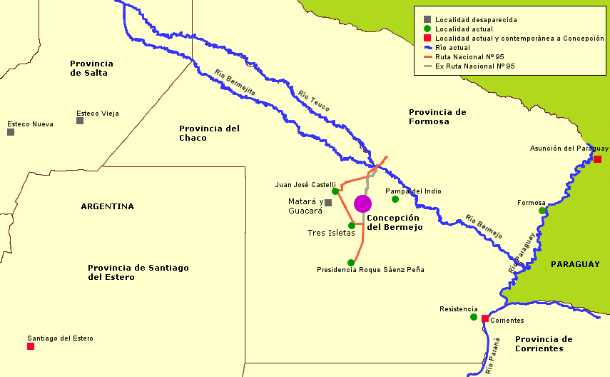
| Description | A map showing Concepción del Bermejo. Political division and rivers correspond to current shape, but there are some old cities and some dead cities. |
| Date | |
| Source | Own work |
| Author | User Pertile in es.wikipedia |
Spanish legends on map:
- Localidad desaparecida: dead city
- Localidad actual: current city
- Localidad actual y contemporánea a Concepción: current city that existed by the time of Concepción
- Río actual: current river
- Ruta Nacional Nº 95: National Road Nº 95
Licensing edit
I, the copyright holder of this work, hereby publish it under the following licenses:

|
Permission is granted to copy, distribute and/or modify this document under the terms of the GNU Free Documentation License, Version 1.2 or any later version published by the Free Software Foundation; with no Invariant Sections, no Front-Cover Texts, and no Back-Cover Texts. A copy of the license is included in the section entitled GNU Free Documentation License. |
| This file is licensed under the Creative Commons Attribution-Share Alike 3.0 Unported license. | ||
| ||
| This licensing tag was added to this file as part of the GFDL licensing update. |
You may select the license of your choice.
File history
Click on a date/time to view the file as it appeared at that time.
| Date/Time | Thumbnail | Dimensions | User | Comment | |
|---|---|---|---|---|---|
| current | 18:30, 7 October 2007 | | 855 × 528 (56 KB) | Pertile (talk | contribs) | |
| 17:06, 2 October 2007 |  | 855 × 528 (55 KB) | Pertile (talk | contribs) | ||
| 17:03, 2 October 2007 |  | 855 × 528 (56 KB) | Pertile (talk | contribs) | {{Information |Description=A map showing Concepción del Bermejo. Political division and rivers correspond to current shape, but there are some old cities and some dead cities. |Source=self-made |Date=2007.10.02 |Author= [http://es.wikipedia.org/wiki/Usua |
You cannot overwrite this file.
File usage on Commons
There are no pages that use this file.
File usage on other wikis
The following other wikis use this file:
- Usage on ast.wikipedia.org
- Usage on es.wikipedia.org
- Río Teuco
- Río Bermejo
- Alonso de Vera y Aragón y Calderón
- Concepción de Buena Esperanza
- Nuestra Señora de Talavera
- Matará (encomienda)
- Guacará (encomienda)
- Formosa (ciudad)
- Juan de Lacoizqueta
- Manuel Maciel y Cabral de Alpoin
- Francisco García Romero
- Río Bermejito
- Baltasar Maciel y de la Cueva
- Pedro Gómez de Aguiar
- Gaspar de Sequeira
- Antón Martín de Don Benito y Yupanqui
- Juan Díaz Moreno de Cerqueyra
- Domingo Díaz Moreno
- Usage on ja.wikipedia.org
- Usage on lt.wikipedia.org
- Usage on pt.wikipedia.org
- Usage on www.wikidata.org