File:Map of Illinois highlighting counties without township government.svg

Size of this PNG preview of this SVG file: 187 × 337 pixels. Other resolutions: 133 × 240 pixels | 266 × 480 pixels | 426 × 768 pixels | 568 × 1,024 pixels | 1,136 × 2,048 pixels.
Original file (SVG file, nominally 187 × 337 pixels, file size: 36 KB)
Captions
Captions
Add a one-line explanation of what this file represents
Summary
edit
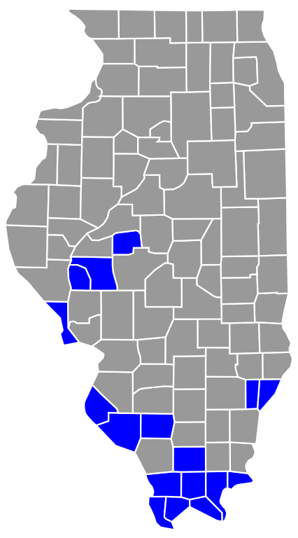
| Description | This is a map highlighting Illinois counties without township government (Precincts not townships). |
| Date | |
| Source | Own work |
| Author | Own work Derived from David Benbennick's map. For more information, see Commons:United States county locator maps. |
| SVG development |
Licensing
edit
| I, the copyright holder of this work, release this work into the public domain. This applies worldwide. In some countries this may not be legally possible; if so: I grant anyone the right to use this work for any purpose, without any conditions, unless such conditions are required by law. |
File history
Click on a date/time to view the file as it appeared at that time.
| Date/Time | Thumbnail | Dimensions | User | Comment | |
|---|---|---|---|---|---|
| current | 03:49, 23 January 2021 | | 187 × 337 (36 KB) | Elli (talk | contribs) | Use a different map base that distinguishes between adjacent counties. |
| 20:48, 19 April 2013 |  | 3,453 × 6,157 (84 KB) | Dewclouds (talk | contribs) | Fixed typo in source to add Randolph County. | |
| 18:58, 24 February 2007 |  | 3,453 × 6,157 (84 KB) | Dual Freq (talk | contribs) | This is a map highlighting Illinois counties without township government (Precincts not townships). Modification of David Benbennick's map. For more information, see Commons:United States county locator maps. {{PD-self}} [[Categor |
You cannot overwrite this file.
File usage on Commons
There are no pages that use this file.
File usage on other wikis
The following other wikis use this file:
- Usage on en.wikipedia.org
- Usage on fr.wikipedia.org
- Usage on ro.wikipedia.org