File:Map of Javne cs.png
Map_of_Javne_cs.png (300 × 200 pixels, file size: 63 KB, MIME type: image/png)
Captions
Captions
| Description |
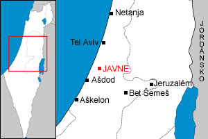
Čeština: Lokalizace Javne v Izraeli. English: Localization of Yavne within Israel. |
||
| Date | (UTC) | ||
| Source | |||
| Author |
|
||
| Permission (Reusing this file) |
|
||
| Other versions | Derivative works of this file: Map of Rison le-Cijon cs.png |
[[C
- derivative work: Faigl.ladislav (talk)
|Permission= |other_versions=Derivative works of this file: Map of Rison le-Cijon cs.png }}
| This is a retouched picture, which means that it has been digitally altered from its original version. The original can be viewed here: Localització de Holon.png:
|
| |
This work has been released into the public domain by its author, Example, at the [[::|English Wikipedia]] project. This applies worldwide. In case this is not legally possible: |
Original upload log edit
This image is a derivative work of the following images:
- File:Localització_de_Holon.png licensed with PD-user-w
- 2006-09-16T09:09:00Z Rf 300x200 (8864 Bytes) {{Information |Description=Localization of Holon within Israel. |Source=Own work |Date=Sep 2006 |Author=Myself, done with Photoshop |Permission={{PD-user-w|ca|wikipedia|Rf}} |other_versions={{DerivativeVersions|Map of Rison le-Cijon cs.png}} }} [[Category:Maps of municipaliti
Uploaded with derivativeFX
[[Category:Maps
- derivative work: Faigl.ladislav(talk)
|Permission= |other_versions=Derivative works of this file: Map of Rison le-Cijon cs.png }}
| This is a retouched picture, which means that it has been digitally altered from its original version. The original can be viewed here: Map of Cholon cs.png:
|
| |
This work has been released into the public domain by its author, Example, at the [[::|English Wikipedia]] project. This applies worldwide. In case this is not legally possible: |
| |
This work has been released into the public domain by its author, , at the English Wikipedia project. This applies worldwide. In case this is not legally possible: |
Original upload log edit
This image is a derivative work of the following images:
- File:Map_of_Cholon_cs.png licensed with PD-user-w, PD-user-w/en
- 2009-02-15T01:56:23Z Faigl.ladislav 300x200 (67048 Bytes) {{Information |Description=Localization of Holon within Israel. |Source=*[[:File:Localització_de_Holon.png|]] |Date=2009-02-15 01:56 (UTC) |Author=*[[:File:Localització_de_Holon.png|]]: Myself, done with Photoshop |Permissi
Uploaded with derivativeFX
[[Category:Maps of municipalities of Isr
- derivative work: Faigl.ladislav(talk)
|Permission= |other_versions=Derivative works of this file: Map of Rison le-Cijon cs.png }}
| This is a retouched picture, which means that it has been digitally altered from its original version. The original can be viewed here: Map of Nes Cijona cs.png:
|
| |
This work has been released into the public domain by its author, Example, at the [[::|English Wikipedia]] project. This applies worldwide. In case this is not legally possible: |
| |
This work has been released into the public domain by its author, , at the English Wikipedia project. This applies worldwide. In case this is not legally possible: |
Original upload log edit
This image is a derivative work of the following images:
- File:Map_of_Nes_Cijona_cs.png licensed with PD-user-w, PD-user-w/en
- 2009-02-15T11:24:47Z Faigl.ladislav 300x200 (65993 Bytes) {{Information |Description={{cs|Lokalizace Nes Cijony v Izraeli.}}{{en|Localization of Ness Tziona within Israel.}} |Source=*[[:File:Map_of_Cholon_cs.png|]] |Date=2009-02-15 11:24 (UTC) |Author=*[[:File:Map_of_Cholon_cs.png|]
Uploaded with derivativeFX
File history
Click on a date/time to view the file as it appeared at that time.
| Date/Time | Thumbnail | Dimensions | User | Comment | |
|---|---|---|---|---|---|
| current | 11:28, 15 February 2009 | | 300 × 200 (63 KB) | Faigl.ladislav (talk | contribs) | {{Information |Description={{cs|Lokalizace Javne v Izraeli.}}{{en|Localization of Yavne within Israel.}} |Source=*File:Map_of_Nes_Cijona_cs.png |Date=2009-02-15 11:28 (UTC) |Author=*File:Map_of_Nes_Cijona_cs.png: *[[:File:Map_of_Cholon_cs.png| |
You cannot overwrite this file.
File usage on Commons
The following 3 pages use this file: