File:Map of Jefferson County, Va. photographed for the Bureau of Topographical Engineers Oct., 1862. LOC lva0000085.jpg

Size of this preview: 770 × 599 pixels. Other resolutions: 308 × 240 pixels | 617 × 480 pixels | 987 × 768 pixels | 1,280 × 996 pixels | 2,560 × 1,993 pixels | 13,650 × 10,625 pixels.
Original file (13,650 × 10,625 pixels, file size: 18.25 MB, MIME type: image/jpeg)
Captions
Captions
Add a one-line explanation of what this file represents
Summary edit
| Warning | The original file is very high-resolution. It might not load properly or could cause your browser to freeze when opened at full size. |
|---|
| Description |
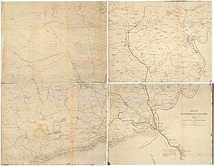
English: Shows Jefferson County before the formation of West Virginia in 1863. |
||
| Title | Map of Jefferson County, Va. photographed for the Bureau of Topographical Engineers Oct., 1862. | ||
| Shelf ID | https://www.loc.gov/item/lva0000085/ | ||
| Date | |||
| Source | https://www.loc.gov/item/lva0000085/ | ||
| Author | United States. Topographical Bureau; Brown, Samuel Howell | ||
| Permission (Reusing this file) |
|
||
| Other versions |
|
||
| Location | Jefferson County · United States · West Virginia | ||
| Part of | Military Battles And Campaigns · American Memory · Civil War Maps · Geography And Map Division | ||
| Subject | Jefferson County · Civil War · United States · Maps · West Virginia · Jefferson County (W. Va.) · History |


Licensing edit
|
This is a faithful photographic reproduction of a two-dimensional, public domain work of art. The work of art itself is in the public domain for the following reason:
The official position taken by the Wikimedia Foundation is that "faithful reproductions of two-dimensional public domain works of art are public domain".
This photographic reproduction is therefore also considered to be in the public domain in the United States. In other jurisdictions, re-use of this content may be restricted; see Reuse of PD-Art photographs for details. | ||||
File history
Click on a date/time to view the file as it appeared at that time.
| Date/Time | Thumbnail | Dimensions | User | Comment | |
|---|---|---|---|---|---|
| current | 12:17, 24 May 2018 | | 13,650 × 10,625 (18.25 MB) | Fæ (talk | contribs) | LOC Maps https://www.loc.gov/item/lva0000085/ #14140 |
You cannot overwrite this file.
File usage on Commons
The following page uses this file: