File:Map of Litbel 1919.svg

Size of this PNG preview of this SVG file: 745 × 600 pixels. Other resolutions: 298 × 240 pixels | 596 × 480 pixels | 954 × 768 pixels | 1,272 × 1,024 pixels | 2,545 × 2,048 pixels | 4,100 × 3,300 pixels.
Original file (SVG file, nominally 4,100 × 3,300 pixels, file size: 328 KB)
Captions
Captions
Add a one-line explanation of what this file represents
Summary
edit| Description |
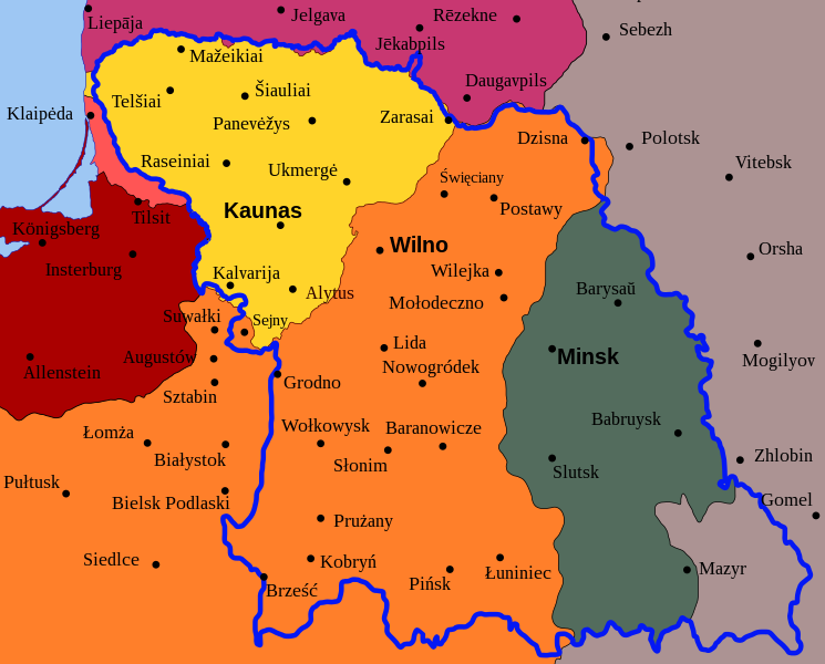
Map of planned border (thick blue line) for the en:Lithuanian–Belorussian Soviet Socialist Republic (commonly known as Litbel) superimposed on state borders in 1922. Germany
Latvia
Poland
Lithuania
Klaipėda Region (detached from Germany by the Treaty of Versailles) |
| Date | |
| Source | Own work by uploader using Inkscape. Data is form Lietuvos istorijos atlasas (ISBN 5-415-01577-9) |
| Author | Renata3 |
| Permission (Reusing this file) |
Copyleft |
| Other versions |
|


Licensing
edit
I, the copyright holder of this work, hereby publish it under the following licenses:
This file is licensed under the Creative Commons Attribution-Share Alike 3.0 Unported license.
- You are free:
- to share – to copy, distribute and transmit the work
- to remix – to adapt the work
- Under the following conditions:
- attribution – You must give appropriate credit, provide a link to the license, and indicate if changes were made. You may do so in any reasonable manner, but not in any way that suggests the licensor endorses you or your use.
- share alike – If you remix, transform, or build upon the material, you must distribute your contributions under the same or compatible license as the original.

|
Permission is granted to copy, distribute and/or modify this document under the terms of the GNU Free Documentation License, Version 1.2 or any later version published by the Free Software Foundation; with no Invariant Sections, no Front-Cover Texts, and no Back-Cover Texts. A copy of the license is included in the section entitled GNU Free Documentation License. |
You may select the license of your choice.
File history
Click on a date/time to view the file as it appeared at that time.
| Date/Time | Thumbnail | Dimensions | User | Comment | |
|---|---|---|---|---|---|
| current | 19:02, 20 August 2010 | | 4,100 × 3,300 (328 KB) | Tomasz Bladyniec (talk | contribs) | Ups, wrong proportions. |
| 18:54, 20 August 2010 |  | 6,187 × 4,240 (254 KB) | Tomasz Bladyniec (talk | contribs) | I've made some changes in city names. Names should be writted in version used that time. So: 1. No Olsztyn, Elbląg, Słupsk and Gdańsk. Changed into German names. 2. Cities in eastern Poland changed from Belarusian to Polish. 3. Cities in Russia changed | |
| 06:22, 28 August 2008 |  | 4,100 × 3,300 (314 KB) | Renata3 (talk | contribs) | blue line | |
| 05:59, 28 August 2008 |  | 4,100 × 3,300 (314 KB) | Renata3 (talk | contribs) | fix | |
| 05:58, 28 August 2008 |  | 4,100 × 3,300 (315 KB) | Renata3 (talk | contribs) | {{Information |Description= Map of planned border (thick green line) for en:Lithuanian–Belorussian Soviet Socialist Republic (commonly known as Litbel) superimposed on European borders in 1920. |Source=Own work by uploader using Inkscape. |Date= | |
You cannot overwrite this file.
File usage on Commons
The following 3 pages use this file:
File usage on other wikis
The following other wikis use this file:
- Usage on ar.wikipedia.org
- Usage on azb.wikipedia.org
- Usage on en.wikipedia.org
- Usage on et.wikipedia.org
- Usage on fa.wikipedia.org
- Usage on fi.wikipedia.org
- Usage on id.wikipedia.org
- Usage on ja.wikipedia.org
- Usage on ko.wikipedia.org
- Usage on lv.wikipedia.org
- Usage on ro.wikipedia.org
- Usage on ru.wikipedia.org
- Usage on simple.wikipedia.org
- Usage on sv.wikipedia.org
- Usage on th.wikipedia.org
- Usage on tr.wikipedia.org
- Usage on vi.wikipedia.org
- Usage on www.wikidata.org