File:Map of Mashhad, 1954.jpg
Original file (3,582 × 4,231 pixels, file size: 3.55 MB, MIME type: image/jpeg)
Captions
Captions
Summary
edit
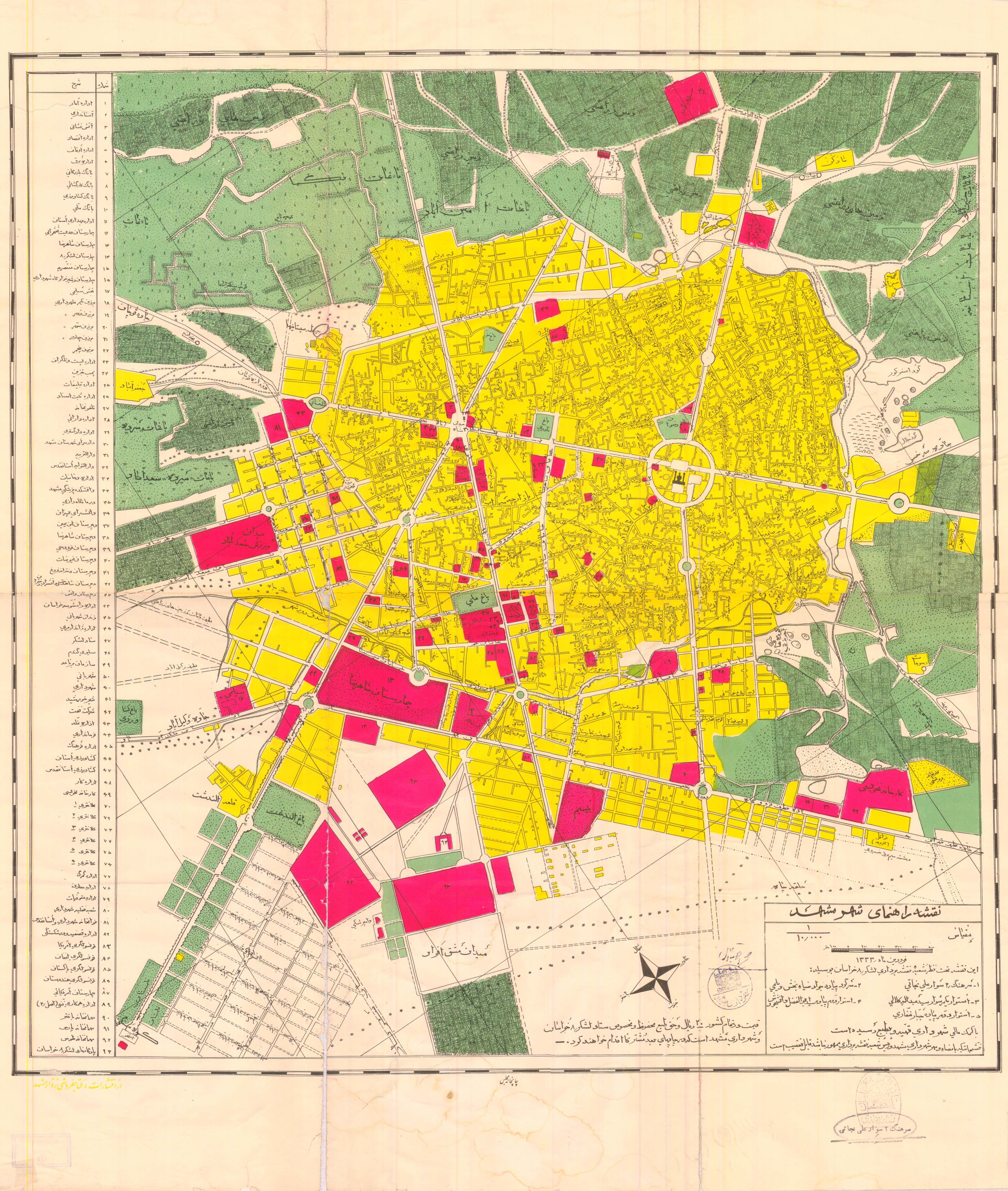
| Title |
Map of Mashhad |
| Description |
فارسی: نقشه راهنمای مشهد |
| Source | https://web.archive.org/web/20130807153131/http://geographyscience.persiangig.com/Map/Mashhad.jpg |
| Creator |
فارسی: ستاد لشکر ۸ خراسان و شهرداری مشهد این نقشه تحت نظر شعبهٔ نقشهبرداری لشکر ۸ خراسان بوسیله: سرهنگ ۲ سوار علی نجاتی، سرگرد پیاده جواد ضیاءبخش، استوار یکم سوار سید عبدالله کلالی، استوار دوم پیاده سید ابوالفضل دانشجووش، استوار دوم پیاده جبار غفاری با کمک مالی شهرداری تهیه و بطبع رسیده است. |
| Geotemporal data | |
| Date depicted |
فارسی: فروردین ۱۳۳۳ |
| Map location | Mashhad |
| Map type | cartographic image |
| Scale | 1:10,000 |
| Georeferencing | If inappropriate please set warp_status = skip to hide. |
| Bibliographic data | |
| Language | Persian |
| Place of publication | Iran |
| Publisher |
فارسی: انتشارات کتابفروشی زوار مشهد |
| Printed by |
فارسی: چاپخانه مجلس |
Licensing
edit
This image is in the public domain because it is a mere mechanical scan or photocopy of a public domain original, or – from the available evidence – is so similar to such a scan or photocopy that no copyright protection can be expected to arise. The original itself is in the public domain for the following reason:
This tag is designed for use where there may be a need to assert that any enhancements (eg brightness, contrast, colour-matching, sharpening) are in themselves insufficiently creative to generate a new copyright. It can be used where it is unknown whether any enhancements have been made, as well as when the enhancements are clear but insufficient. For known raw unenhanced scans you can use an appropriate {{PD-old}} tag instead. For usage, see Commons:When to use the PD-scan tag.  |
File history
Click on a date/time to view the file as it appeared at that time.
| Date/Time | Thumbnail | Dimensions | User | Comment | |
|---|---|---|---|---|---|
| current | 21:06, 20 November 2020 | | 3,582 × 4,231 (3.55 MB) | Hanooz (talk | contribs) | Cropped 1 % vertically using CropTool with lossless mode. |
| 20:57, 20 November 2020 |  | 3,582 × 4,280 (1.99 MB) | Hanooz (talk | contribs) | =={{int:filedesc}}== {{Map |title = Map of Mashhad |description = {{fa|نقشهٔ شهر مشهد}} |legend = |author = {{fa|ستاد لشکر ۸ خراسان و شهرداری مشهد<br>این نقشه تحت نظر شعبهٔ نقشهبرداری لشکر ۸ خراسان بوسیله:<br>سرهنگ ۲ سوار علی نجاتی، سرگرد پیاده جواد ضیاءبخش، استوار یکم سوار سید عبدالله کلالی، استوار دوم پیاده سید ابوالفضل دانشجووش، استوار دوم پیاده جبار غفاری<br>با کمک مالی شهرداری تهیه و بطبع رسیده است.}} |image = |date... |
You cannot overwrite this file.
File usage on Commons
There are no pages that use this file.