File:Map of Massachusetts highlighting the Springfield metropolitan area.svg

Size of this PNG preview of this SVG file: 800 × 489 pixels. Other resolutions: 320 × 196 pixels | 640 × 391 pixels | 1,024 × 626 pixels | 1,280 × 782 pixels | 2,560 × 1,565 pixels | 2,976 × 1,819 pixels.
Original file (SVG file, nominally 2,976 × 1,819 pixels, file size: 47 KB)
Captions
Captions
Add a one-line explanation of what this file represents
Summary
edit
| Description |
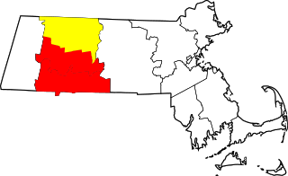
English: Map of the Springfield-Greenfield town combined statistical area in Massachusetts showing the Greenfield town micropolitan statistical area Springfield metropolitan area |
||
| Date | |||
| Source | Own work, derived from maps by David Benbennick | ||
| Author | User:Simtropolitan | ||
| Permission (Reusing this file) |
|
File history
Click on a date/time to view the file as it appeared at that time.
| Date/Time | Thumbnail | Dimensions | User | Comment | |
|---|---|---|---|---|---|
| current | 17:04, 22 March 2019 | | 2,976 × 1,819 (47 KB) | Simtropolitan (talk | contribs) | Highlighting Franklin County in yellow, part of CSA, not MSA per https://www2.census.gov/geo/maps/metroarea/stcbsa_pg/Feb2013/cbsa2013_MA.pdf |
| 16:08, 27 June 2018 |  | 2,976 × 1,819 (47 KB) | Simtropolitan (talk | contribs) | {{Information |description ={{en|1=Map of the {{w|Springfield metropolitan area, Massachusetts|Springfield metropolitan area}} in {{w|Massachusetts}}}} |date =2018-06-27 |source =Own work, derived from maps by David Benbennick |author ={{w|User:Simtropolitan}} |permission ={{PD-self}} }} Category:Locator maps of Massachusetts |
You cannot overwrite this file.
File usage on Commons
The following page uses this file:
File usage on other wikis
The following other wikis use this file:
- Usage on es.wikipedia.org
- Usage on ur.wikipedia.org
- Usage on www.wikidata.org