File:Map of North and South Carolina WDL9596.png
Size of this preview: 800 × 592 pixels. Other resolutions: 320 × 237 pixels | 640 × 474 pixels | 1,024 × 758 pixels | 1,280 × 948 pixels | 1,383 × 1,024 pixels.
Original file (1,383 × 1,024 pixels, file size: 2.37 MB, MIME type: image/png)
Captions
Captions
Add a one-line explanation of what this file represents
Summary edit
| Author |
Русский: Бурр, Дэвид Г., 1803-1875 гг.
Français : Burr, David H., 1803-1875
English: Burr, David H., 1803-1875
中文:大卫·伯尔,1803-1875 年
Português: Burr, David H., 1803-1875
العربية: ديفيد بور، 1803-1875
Español: Burr, David H., 1803-1875 |
| Title |
Русский: Карта штатов Северная Каролина и Южная Каролина
Français : Carte de la Caroline du Nord et du Sud
English: Map of North and South Carolina
中文:北卡罗来纳州和南卡罗来纳州地图
Português: Mapa da Carolina do Sul e da Carolina do Norte
العربية: خريطة نورث وساوث كارولينا
Español: Mapa de Carolina del Norte y del Sur |
| Description |
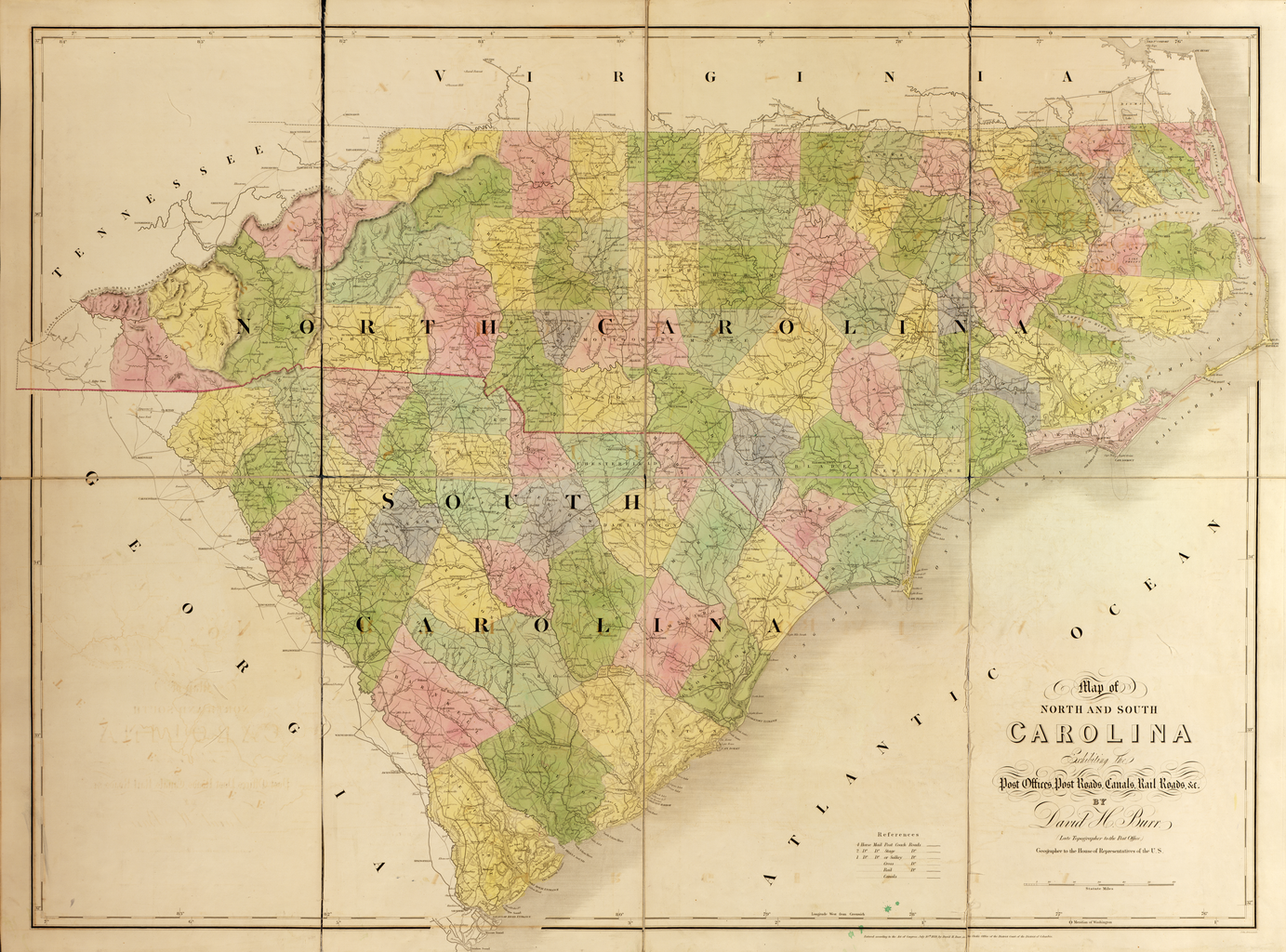
Русский: Дэвид Г. Бурр (1803–1875 гг.), землемер и картограф, служил топографом Почтового департамента США в 1832–1838 гг. и географом Палаты представителей в 1838–1847 гг. Под руководством генерального почтмейстера Бурр собирал от почтмейстеров всей страны информацию о транспортных маршрутах – почтовых трактах, железных дорогах и каналах, а также о расположении почтовых отделений с целью выпуска большого комплекта государственных и региональных карт. Опубликованный в 1839 г. известной лондонской картографической фирмой Джона Эрроусмита, "Американский атлас" Бурра представлял подробную картину заселения и транспортных маршрутов в Соединенных Штатах Америки за несколько десятилетий до Гражданской войны. Здесь представлена составленная Бурром карта штатов Северная Каролина и Южная Каролина, одна из 13 карт атласа. Чарльстон, штат Южная Каролина, был наиболее важным атлантическим портом к югу от Балтимора и узловой станцией одной из старейших и, в течение некоторого времени, самых протяженных железных дорог в мире. В 1827 г. компания "South Carolina Canal and Rail Road Company" получила разрешение и в 1833 г. начала эксплуатацию линии железной дороги протяженностью 219 километров от Чарльстона до Гамбурга, штат Южная Каролина. Главным назначением железной дороги была перевозка сельскохозяйственной продукции из внутренних районов штата к побережью. По сравнению с Южной Каролиной штат Северная Каролина был в то время малонаселенным и имел немного больших поселков или городов.
Каналы; Почтовые тракты; Почтовая служба; Железные дороги Français : Géomètre et cartographe, David H. Burr (1803-1875) fut topographe au Département des Postes des États-Unis entre 1832 et 1838, puis géographe à la Chambre des représentants entre 1838 et 1847. Sous la direction du Maître des postes général, Burr compila les informations fournies par les maîtres des postes à travers le pays concernant les routes (routes postières, chemins de fer et cours d'eau) et l'emplacement des bureaux de poste afin de réaliser une importante série de cartes des États et des régions. Publié en 1839 par l'éminente société cartographique de John Arrowsmith, L'atlas américain de Burr représente de façon détaillée la répartition du peuplement et du transport aux États-Unis quelques dizaines d'années avant la guerre de Sécession. La carte de Burr exposée ici représentant la Caroline du Nord et la Caroline du Sud fait partie des 13 cartes de l'atlas. Charleston, en Caroline du Sud, était le port atlantique le plus important au sud de Baltimore et le terminus du plus vieux et, pendant quelques temps, du plus long chemin de fer du monde. La South Carolina Canal and Rail Road Company fut affrétée en 1827 et commença à fonctionner en 1833 sur une ligne de 219 km de long allant de Charleston à Hamburg, en Caroline du Sud. Le principal objectif du chemin de fer était de transporter les produits agricoles de l'intérieur de l'État jusqu'à la côte. En comparaison avec la Caroline du Sud, la Caroline du Nord était en ce temps-là faiblement peuplée et ne comptait qu'un petit nombre de villes et grandes villes.
Canaux; Routes postières; Service postal; Chemins de fer English: David H. Burr (1803–75) was a surveyor and cartographer, who served as topographer to the United States Post Office Department in 1832–38 and as geographer to the House of Representatives in 1838–47. Under the direction of the postmaster general, Burr compiled information from postmasters throughout the country about transportation routes—post roads, railroads, and canals—and the location of post offices to produce a large set of state and regional maps. Published in 1839 by the prominent London mapmaking firm of John Arrowsmith, Burr’s The American Atlas offers a detailed picture of settlement and transportation patterns in the United States in the decades before the Civil War. Shown here is Burr’s map of North Carolina and South Carolina, one of 13 maps in the atlas. Charleston, South Carolina was the most important Atlantic port south of Baltimore, and the terminus of one of the oldest, and for a time the longest, railroads in the world. The South Carolina Canal and Rail Road Company was chartered in 1827 and in 1833 began operating a 219-kilometer line from Charleston to Hamburg, South Carolina. The main purpose of the railroad was to carry agricultural produce from the interior of the state to the coast. Compared with South Carolina, North Carolina was at this time sparsely populated and had few large towns or cities.
Canals; Post roads; Postal service; Railroads 中文:大卫·伯尔(David H. Burr,1803-1875 年)是一位测量员和制图员,于 1832—1838 年担任美国邮政署地形学者,1838—1847 年担任众议院地理学家。在邮政署长的指导下,伯尔汇编了全国各地邮政局长提供的有关运输路线(邮路、铁路和运河)以及邮局位置的信息,制作了大量州地图和地区地图。伯尔的 《美国地图册》由伦敦著名制图商约翰·阿罗史密斯 (John Arrowsmith) 于 1839 年出版,详细描绘了美国在内战前数十年的聚居和运输模式。这里展示的是伯尔绘制的北卡罗来纳州和南卡罗来纳州地图,是地图册中的 13 幅地图之一。南卡罗来纳州查尔斯顿市是巴尔的摩南部最重要的大西洋港口城市,也是世界上最古老、也一度是最长的铁路线的终点站。南卡罗来纳州运河和铁路公司于 1827 年获得经营特许,并于 1833 年开始管理查尔斯顿和南卡罗来纳州汉堡市之间的 219 公里长的铁路线。这条铁路主要用于将该州内陆农产品运输到沿海。与南卡罗来纳州相比,这一时期的北卡罗莱纳州人口稀少,少有大型市镇。
运河; 邮路; 邮政服务; 铁路 Português: David H. Burr (1803-1875) foi um agrimensor e cartógrafo, que atuou como topógrafo para o Departamento de Correios dos Estados Unidos entre 1832 e 1838 e como geógrafo para a Câmara dos Representantes entre 1838 e 1847. Sob a direção do reponsável geral dos correios, Burr compilou informações dos responsáveis dos correios em todo o país sobre rotas de transporte—estradas de correios, ferrovias e canais—e o local dos postos de correios para a produção de um grande conjunto de mapas estaduais e regionais. Publicado em 1839 pela proeminente empresa de cartografia londrina de John Arrowsmith, O atlas americano de Burr fornece um quadro detalhado da disposição das colônias e do transporte nos Estados Unidos nas décadas anteriores à Guerra Civil. Aqui é mostrado o mapa de Burr da Carolina do Sul e da Carolina do Norte, um dos 13 mapas do atlas. Charleston, na Carolina do Sul, foi o mais importante porto atlântico ao sul de Baltimore, e o terminal de uma das mais antigas, e por um tempo a mais longa, ferrovia do mundo. A South Carolina Canal and Rail Road Company foi fundada em 1827 e em 1833 teve início a operação de uma linha de 219 quilômetros de Charleston a Hamburgo, na Carolina do Sul. O principal objetivo da ferrovia era o de transportar produtos agrícolas do interior do estado para o litoral. Em comparação com a Carolina do Sul, a Carolina do Norte era pouco povoada nesta época e tinha poucas vilas grandes ou cidades.
Canais; Estradas do correio; Serviço postal; Ferrovias العربية: كان ديفيد بور (1803-1875) ماسح أراضٍ ورسام خرائط، وقد شغل منصب طبوغرافي تابع لإدارة مكاتب البريد الأمريكية في الفترة ما بين 1832-1838، كما عَمِل جغرافياً تابعاً لمجلس النواب في الفترة ما بين 1838-1847. جمع بور معلومات من مدراء مكاتب البريد الموجودة في جميع أنحاء الدولة حول مسارات النقل— طرق نقل البريد والسكك الحديدية والقنوات— ومواقع مكاتب البريد لتصميم مجموعة كبيرة من خرائط الولايات والأقاليم، وذلك بتوجيه من المدير العام لمكتب البريد. نشرت مؤسسة جون آروسميث البارزة لصنع الخرائط بلندن الأطلس الأمريكي بقلم بور عام 1839، وهو يعرض صورة مفصلة لأنماط الاستيطان والنقل في الولايات المتحدة في العقود السابقة للحرب الأهلية. مبينة هنا خريطة نورث وساوث كارولينا من تصميم بور، وهي واحدة من بين الخرائط الـ13 الموجودة بالأطلس. مَثّلت تشارلستون، بساوث كارولينا، أهم ميناء بحري يطل على المحيط الأطلنطي ويقع جنوب بالتيمور، والمحطة النهائية لأحد أقدم خطوط السكك الحديدية في العالم، الذي ظل أطول خط لفترة من الوقت. تم الاتفاق مع الشركة المتعهدة بحفر قناة ساوث كارولينا وإنشاء خط السكك الحديدية عام 1827، وبدأت العمل في 1833 على إنشاء خط يبلغ طوله 219 كيلومتراً يمتد من تشارلستون حتى هامبورغ بساوث كارولينا. تَمَثّل الهدف الأساسي من إنشاء خط السكة الحديدية في نقل الإنتاج الزراعي من داخل الولاية حتى الساحل. وبالمقارنة مع ساوث كارولينا، لم تكن نورث كارولينا حينئذ مأهولة بالسكان ولم يكن بها إلا بضع مدن أو بلدات كبيرة.
القنوات; طرق نقل البريد; خدمات البريد; السكك الحديدية Español: David H. Burr (1803-1875) era topógrafo y cartógrafo, y se desempeñó como topógrafo en el Departamento de Correos de los Estados Unidos de 1832 a 1838 y como geógrafo para la Cámara de Representantes entre 1838 y 1847. Bajo la dirección del director general de correos, Burr recopiló información de los administradores de correo de todo el país acerca de las rutas de transporte (carreteras, ferrocarriles y canales de rutas de correos) y la ubicación de las oficinas de correos para producir un gran conjunto de mapas estatales y regionales. Publicado en 1839 por la prominente empresa de cartografía londinense de John Arrowsmith, El atlas estadounidense de Burr ofrece un panorama detallado de los patrones de asentamiento y el transporte en los Estados Unidos en las décadas anteriores a la Guerra Civil. Aquí se muestra el mapa de Burr de Carolina del Norte y Carolina del Sur: uno de los 13 mapas del atlas. Charleston, Carolina del Sur, era el puerto más importante del Atlántico al sur de Baltimore, y la terminal de uno de los más antiguos (y por un tiempo el más largo) ferrocarriles del mundo. La empresa South Carolina Canal and Rail Road Company se fundó en 1827 y comenzó a operar en 1833 una línea de 219 kilómetros desde Charleston hasta Hamburgo, Carolina del Sur. El objetivo principal del ferrocarril era llevar los productos agrícolas del interior del estado a la costa. En comparación con Carolina del Sur, Carolina del Norte en ese entonces estaba escasamente poblada y tenía pocas ciudades grandes.
Canales; Rutas de correos; Servicio postal; Ferrocarriles |
| Date | 1839 |
| Medium |
Русский: Карты
Français : Cartes
English: Maps
中文:地图
Português: Mapas
العربية: خرائط
Español: Mapas |
| Dimensions |
English: 1 map from loose-leaf atlas : hand colored, mounted on cloth ; 130 x 130 centimeters or smaller, folded in case 50 x 33 x 7 centimeters |
| Collection |
Русский: Библиотека Конгресса
Français : Bibliothèque du Congrès
English: Library of Congress
中文:国会图书馆
Português: Biblioteca do Congresso
العربية: مكتبة الكونغرس
Español: Biblioteca del Congreso |
| Place of creation |
Русский: Северная Каролина
Français : Caroline du Nord
English: North Carolina
中文:北卡罗来纳州
Português: Carolina do Norte
العربية: كارولاينا الشمالية
Español: Carolina del Norte |
| Source/Photographer |
|
Licensing edit
|
This is a faithful photographic reproduction of a two-dimensional, public domain work of art. The work of art itself is in the public domain for the following reason:
The official position taken by the Wikimedia Foundation is that "faithful reproductions of two-dimensional public domain works of art are public domain".
This photographic reproduction is therefore also considered to be in the public domain in the United States. In other jurisdictions, re-use of this content may be restricted; see Reuse of PD-Art photographs for details. | ||||
File history
Click on a date/time to view the file as it appeared at that time.
| Date/Time | Thumbnail | Dimensions | User | Comment | |
|---|---|---|---|---|---|
| current | 04:01, 12 March 2014 | | 1,383 × 1,024 (2.37 MB) | Fæ (talk | contribs) | =={{int:filedesc}}== {{Artwork |artist = |author ={{ru|1=Бурр, Дэвид Г., 1803-1875 гг.}} {{fr|1=Burr, David H., 1803-1875}} {{en|1=Burr, David H., 1803-1875}} {{zh|1=大卫·伯尔,1803-1875 年}} {{pt|1=Burr, David H., 1803-1875}} {{ar|... |
You cannot overwrite this file.
File usage on Commons
The following page uses this file: