File:Map of Oresund 1705.jpg

Size of this preview: 434 × 599 pixels. Other resolutions: 174 × 240 pixels | 348 × 480 pixels | 556 × 768 pixels | 742 × 1,024 pixels | 2,174 × 3,000 pixels.
Original file (2,174 × 3,000 pixels, file size: 5.8 MB, MIME type: image/jpeg)
Captions
Captions
Add a one-line explanation of what this file represents
Summary edit
| Description |
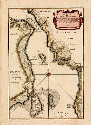
Svenska: Karta över Öresund med text på franska. Texten säger att tullen som fartygen får betala är så stor att den utgör en av de största och bästa inkomstkällorna för den danska kungen.
Utsatt på kartan är bland annat Elseneur (Helsingör) och Elsembourg (Helsingborg), Isle de Huene (Ven), Lanskrona, Malmoe, Malmut eller Elboge (Malmö) samt Copenhague (Köpenhamn). Vid Ven har noterats att här har Tycho Brahe sitt observatorium. |
| Date | |
| Source | https://digitaltmuseum.se/021025731129/karta |
| Author | Charles Inselin |
Licensing edit
|
This work is in the public domain in its country of origin and other countries and areas where the copyright term is the author's life plus 70 years or fewer. This work is in the public domain in the United States because it was published (or registered with the U.S. Copyright Office) before January 1, 1929. | |
| This file has been identified as being free of known restrictions under copyright law, including all related and neighboring rights. | |
File history
Click on a date/time to view the file as it appeared at that time.
| Date/Time | Thumbnail | Dimensions | User | Comment | |
|---|---|---|---|---|---|
| current | 04:46, 8 August 2019 | | 2,174 × 3,000 (5.8 MB) | Jsdo1980 (talk | contribs) | User created page with UploadWizard |
You cannot overwrite this file.
File usage on Commons
There are no pages that use this file.