File:Map of Russia - Southern Federal District (2018 composition, Crimea claimed).svg

Size of this PNG preview of this SVG file: 800 × 462 pixels. Other resolutions: 320 × 185 pixels | 640 × 369 pixels | 1,024 × 591 pixels | 1,280 × 738 pixels | 2,560 × 1,477 pixels | 1,092 × 630 pixels.
Original file (SVG file, nominally 1,092 × 630 pixels, file size: 61 KB)
Captions
Captions
Add a one-line explanation of what this file represents
Summary
edit.svg&action=edit§ion=1)
| Description |
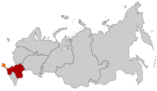
English: Southern Federal District with Crimea shown as claimed territory (orange) |
| Date | (UTC) |
| Source |
This file was derived from: |
| Author |
|
.svg)
.svg)
.svg)
.svg)
| This is a retouched picture, which means that it has been digitally altered from its original version. Modifications: Far Eastern-Siberian border update as of November 2018. The original can be viewed here: Map of Russia - Southern Federal District (2018 composition).svg:
|
Licensing
edit.svg&action=edit§ion=2)
This file is licensed under the Creative Commons Attribution-Share Alike 2.5 Generic license.
- You are free:
- to share – to copy, distribute and transmit the work
- to remix – to adapt the work
- Under the following conditions:
- attribution – You must give appropriate credit, provide a link to the license, and indicate if changes were made. You may do so in any reasonable manner, but not in any way that suggests the licensor endorses you or your use.
- share alike – If you remix, transform, or build upon the material, you must distribute your contributions under the same or compatible license as the original.
Original upload log
edit.svg&action=edit§ion=3)
This image is a derivative work of the following images:
- File:Map of Russia - Southern Federal District (with Crimea claimed).svg licensed with Cc-by-sa-2.5
- File:Map of Russia - Southern Federal District (2018 composition).svg licensed with Cc-by-sa-2.5
- 2018-11-21T20:02:33Z Seryo93 1092x630 (62345 Bytes) == {{int:filedesc}} == {{Information |Description={{en|Map Russia highlighting the Southern [[:en:Federal districts of Russia|Federal districts]] as of 2018-11-03.}} {{es|Ubicación del Distrito Federal Sur en la Federación
Uploaded with derivativeFX
File history
Click on a date/time to view the file as it appeared at that time.
| Date/Time | Thumbnail | Dimensions | User | Comment | |
|---|---|---|---|---|---|
| current | 10:06, 3 December 2018 | | 1,092 × 630 (61 KB) | Seryo93 (talk | contribs) | == {{int:filedesc}} == {{Information |Description={{en|1=Southern Federal District with Crimea shown as claimed territory (orange)}} |Source={{Derived from|Map of Russia - Southern Federal District (with Crimea claimed).svg|Map of Russia - Southern Federal District (2018 composition).svg|display=50}} |Date=2018-12-03 10:04 (UTC) |Author= * [[:File:Map of Russia - Southern Federal District (with Crimea claimed).svg|File:Map of Russia - Southern Federal Distric... |
You cannot overwrite this file.
File usage on Commons
The following page uses this file:
File usage on other wikis
The following other wikis use this file:
- Usage on ar.wikipedia.org
- Usage on az.wikipedia.org
- Usage on ba.wikipedia.org
- Usage on be-tarask.wikipedia.org
- Usage on bg.wikipedia.org
- Usage on ca.wikipedia.org
- Usage on cv.wikipedia.org
- Usage on en.wikipedia.org
- Usage on eo.wikipedia.org
- Usage on es.wikipedia.org
- Usage on fa.wikipedia.org
- Usage on fi.wikipedia.org
- Usage on frr.wikipedia.org
- Usage on hu.wikipedia.org
- Usage on id.wikipedia.org
- Usage on lld.wikipedia.org
- Usage on lt.wikipedia.org
- Usage on lv.wikipedia.org
- Usage on mi.wikipedia.org
- Usage on myv.wikipedia.org
- Usage on pl.wikipedia.org
- Usage on pt.wikipedia.org
- Usage on ru.wikipedia.org
- Usage on sl.wikipedia.org
- Usage on sr.wikipedia.org
- Usage on ta.wikipedia.org
- Usage on uz.wikipedia.org
View more global usage of this file.
.svg)
.svg&oldid=725761233)