File:Map of Slave Coast-1789.jpg

Size of this preview: 800 × 479 pixels. Other resolutions: 320 × 191 pixels | 640 × 383 pixels | 1,024 × 613 pixels | 1,280 × 766 pixels | 3,157 × 1,889 pixels.
Original file (3,157 × 1,889 pixels, file size: 2.45 MB, MIME type: image/jpeg)
Captions
Captions
Add a one-line explanation of what this file represents
| Description |
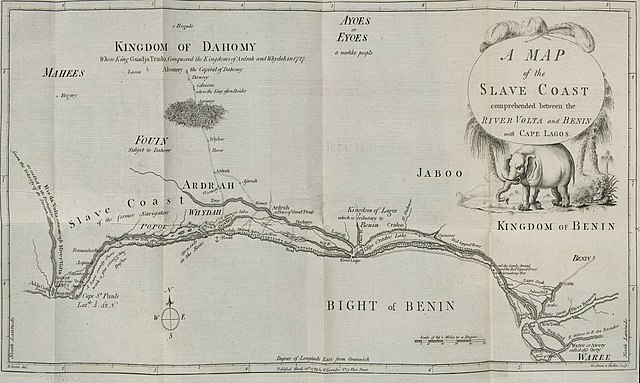
English: Map of the Slave Coast published in Memoirs of the Reign of Bossa Ahádee, King of Dahomy, an Inland Country of Guiney. To Which Are Added, the Author's Journey to Abomey, the Capital; and a Short Account of the African Slave Trade by British slave trader Robert Norris in 1789. |
| Date | |
| Source | http://dcc.newberry.org/collections/olaudah-equiano |
| Author | Norris, Robert |
|
This work is in the public domain in its country of origin and other countries and areas where the copyright term is the author's life plus 100 years or fewer. | |
| This file has been identified as being free of known restrictions under copyright law, including all related and neighboring rights. | |
File history
Click on a date/time to view the file as it appeared at that time.
| Date/Time | Thumbnail | Dimensions | User | Comment | |
|---|---|---|---|---|---|
| current | 11:29, 18 July 2015 | | 3,157 × 1,889 (2.45 MB) | Lubiesque (talk | contribs) | Better copy |
| 23:59, 17 July 2015 |  | 5,261 × 3,148 (2 MB) | Lubiesque (talk | contribs) | Better copy. High resolution | |
| 18:48, 15 April 2010 |  | 957 × 481 (233 KB) | Ji-Elle (talk | contribs) | {{Information |Description={{en|Map of the Slave Coast}} |Source=Gallica [http://gallica.bnf.fr/ark:/12148/bpt6k1057573.image.r=abomey.f3.langFR] from ''Memoirs of the reign of Bossa Ahádee, king of Dahomy, an inland country of Guiney ; to which are add |
You cannot overwrite this file.
File usage on Commons
There are no pages that use this file.
File usage on other wikis
The following other wikis use this file:
- Usage on pt.wikipedia.org