File:Map of The east barbarian 2.png

Size of this preview: 690 × 600 pixels. Other resolutions: 276 × 240 pixels | 552 × 480 pixels | 884 × 768 pixels | 1,077 × 936 pixels.
Original file (1,077 × 936 pixels, file size: 461 KB, MIME type: image/png)
Captions
Captions
Add a one-line explanation of what this file represents
Summary edit
| Description |
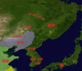
日本語: 4世紀頃の東夷諸国。 |
| Date | |
| Source | File:Whole world - land and oceans 12000.jpg modified by トムル |
| Author | トムル |
Licensing edit
| I, the copyright holder of this work, release this work into the public domain. This applies worldwide. In some countries this may not be legally possible; if so: I grant anyone the right to use this work for any purpose, without any conditions, unless such conditions are required by law. |
File history
Click on a date/time to view the file as it appeared at that time.
| Date/Time | Thumbnail | Dimensions | User | Comment | |
|---|---|---|---|---|---|
| current | 06:10, 14 October 2010 | | 1,077 × 936 (461 KB) | トムル (talk | contribs) | {{Information |Description={{ja|1=4世紀頃の東夷諸国。}} |Source=File:Whole world - land and oceans.jpg |Author=トムル |Date=2010.10.14 |Permission= |other_versions= }} Category:Maps of Manchuria Category:Maps of East Asia |
You cannot overwrite this file.
File usage on Commons
There are no pages that use this file.
File usage on other wikis
The following other wikis use this file: