File:Map of UTA Flight 772.jpg
No higher resolution available.
Map_of_UTA_Flight_772.jpg (462 × 537 pixels, file size: 211 KB, MIME type: image/jpeg)
Captions
Captions
Add a one-line explanation of what this file represents
Summary edit
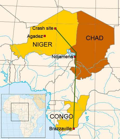
| Description |
العربية: خارطة مسار رحلة UTA رقم 772 في 19 سبتمبر 1989.(لغة إنجليزية)
English: A Map of the flight of UTA Flight 772 on September 19, 1989. (English)
Français : Plan du trajet du vol UTA Flight 772 le 19 septembre 1989. (Anglais) |
| Date | 15 July |
| Source | Based on a BBC news map (but not traced) - Map based on Image:Africa_map_blank.svg by Eric Gaba fr:Sting |
| Author | Eric Gaba and Max Smith |
| Other versions |
Derivative works of this file: |
Licensing edit
I, the copyright holder of this work, hereby publish it under the following licenses:

|
Permission is granted to copy, distribute and/or modify this document under the terms of the GNU Free Documentation License, Version 1.2 or any later version published by the Free Software Foundation; with no Invariant Sections, no Front-Cover Texts, and no Back-Cover Texts. A copy of the license is included in the section entitled GNU Free Documentation License. |
| This file is licensed under the Creative Commons Attribution-Share Alike 3.0 Unported license. | ||
| ||
| This licensing tag was added to this file as part of the GFDL licensing update. |
This file is licensed under the Creative Commons Attribution-Share Alike 2.5 Generic, 2.0 Generic and 1.0 Generic license.
- You are free:
- to share – to copy, distribute and transmit the work
- to remix – to adapt the work
- Under the following conditions:
- attribution – You must give appropriate credit, provide a link to the license, and indicate if changes were made. You may do so in any reasonable manner, but not in any way that suggests the licensor endorses you or your use.
- share alike – If you remix, transform, or build upon the material, you must distribute your contributions under the same or compatible license as the original.
You may select the license of your choice.

File history
Click on a date/time to view the file as it appeared at that time.
| Date/Time | Thumbnail | Dimensions | User | Comment | |
|---|---|---|---|---|---|
| current | 18:30, 26 May 2013 | | 462 × 537 (211 KB) | Colin Douglas Howell (talk | contribs) | Corrected color extents for Chad and Niger to match their actual borders. |
| 08:47, 15 July 2007 |  | 462 × 537 (241 KB) | Megapixie (talk | contribs) | {{Information |Description=A Map of the flight of UTA Flight 772 on September 19, 1989 |Source=Based on a BBC news map (but not traced) - Map based on Image:Africa_map_blank.svg by Eric Gaba fr:Sting |Date=15 July |Author= |
You cannot overwrite this file.
File usage on Commons
The following 4 pages use this file:
File usage on other wikis
The following other wikis use this file:
- Usage on ast.wikipedia.org
- Usage on cs.wikipedia.org
- Usage on de.wikipedia.org
- Usage on es.wikipedia.org
- Usage on fi.wikipedia.org
- Usage on it.wikipedia.org
- Usage on ja.wikipedia.org
- Usage on pl.wikipedia.org
- Usage on pt.wikipedia.org
- Usage on www.wikidata.org
- Usage on zh.wikipedia.org