File:Map of Wisconsin highlighting Bayfield County.svg

Size of this PNG preview of this SVG file: 559 × 599 pixels. Other resolutions: 224 × 240 pixels | 448 × 480 pixels | 717 × 768 pixels | 956 × 1,024 pixels | 1,911 × 2,048 pixels | 4,747 × 5,087 pixels.
Original file (SVG file, nominally 4,747 × 5,087 pixels, file size: 103 KB)
Captions
Captions
Add a one-line explanation of what this file represents
Summary edit
| Description |
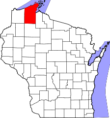
English: This is a locator map showing Bayfield County in Wisconsin. For more information, see Commons:United States county locator maps. |
| Date | |
| Source |
Own work: English: The maps use data from nationalatlas.gov, specifically countyp020.tar.gz on the Raw Data Download page. The maps also use state outline data from statesp020.tar.gz. The Florida maps use hydrogm020.tar.gz to display Lake Okeechobee. |
| Author | David Benbennick |
Licensing edit
| I, the copyright holder of this work, release this work into the public domain. This applies worldwide. In some countries this may not be legally possible; if so: I grant anyone the right to use this work for any purpose, without any conditions, unless such conditions are required by law. |
File history
Click on a date/time to view the file as it appeared at that time.
| Date/Time | Thumbnail | Dimensions | User | Comment | |
|---|---|---|---|---|---|
| current | 00:22, 13 February 2006 | | 4,747 × 5,087 (103 KB) | David Benbennick (talk | contribs) | {{subst:User:Dbenbenn/clm|county=Bayfield County|state=Wisconsin|type=county}} |
| 18:13, 12 February 2006 |  | 4,747 × 5,087 (103 KB) | David Benbennick (talk | contribs) | {{subst:User:Dbenbenn/clm|county=Bayfield County|state=Wisconsin|type=county}} |
You cannot overwrite this file.
File usage on Commons
The following 7 pages use this file:
- Category:Bayfield County, Wisconsin
- Category:Births in Bayfield County, Wisconsin
- Category:Geography of Bayfield County, Wisconsin
- Category:Maps of Bayfield County, Wisconsin
- Category:People of Bayfield County, Wisconsin
- Category:Populated places in Bayfield County, Wisconsin
- Category:Transport in Bayfield County, Wisconsin
File usage on other wikis
The following other wikis use this file:
- Usage on ar.wikipedia.org
- ليوناردز (ويسكونسن)
- باركسديل (ويسكونسن)
- بارنز (ويسكونسن)
- بلدة بايفيلد (ويسكونسن)
- بايفيو (ويسكونسن)
- بيل (ويسكونسن)
- كابل (ويسكونسن)
- كلوفر (ويسكونسن)
- دلتا (ويسكونسن)
- دروموند (ويسكونسن)
- إيلين (ويسكونسن)
- غراند فيو (ويسكونسن)
- هيوز (ويسكونسن)
- أيرون ريفر (ويسكونسن)
- كيلي (ويسكونسن)
- كيستون (ويسكونسن)
- لينكولن (مقاطعة بايفيلد)
- ناماكاغون (ويسكونسن)
- أورينتا (ويسكونسن)
- أولو (ويسكونسن)
- بلسن (ويسكونسن)
- بورت وينغ (ويسكونسن)
- راسيل (مقاطعة بايفيلد)
- تريب (ويسكونسن)
- واشبرن مقاطعة بايفيلد (ويسكونسن)
- مقاطعة بايفيلد (ويسكونسن)
- آشلاند (ويسكونسن)
- واشبرن
- بايفيلد
- ميسون (ويسكونسن)
- قالب:مقاطعة بايفيلد (ويسكونسن)
- Usage on bg.wikipedia.org
- Usage on bpy.wikipedia.org
- Usage on cdo.wikipedia.org
- Usage on ceb.wikipedia.org
- Usage on ce.wikipedia.org
- Usage on cy.wikipedia.org
- Usage on de.wikipedia.org
- Usage on en.wikipedia.org
View more global usage of this file.