File:Map of ancient Naples.png

Size of this preview: 594 × 600 pixels. Other resolutions: 238 × 240 pixels | 475 × 480 pixels | 760 × 768 pixels | 1,114 × 1,125 pixels.
Original file (1,114 × 1,125 pixels, file size: 221 KB, MIME type: image/png)
Captions
Captions
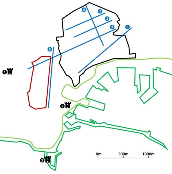
Map showing prominent landmarks in ancient Naples.
The Wall and The castles ( ): (1) Castel sant'Elmo; (2) Castel Nuovo; (3) Castel dell'Ovo.
The main roads: (1) Decumano superiore; (2) Decumano maggiore; (3) Decumano inferiore; (4) Via Duomo; (5) Via Toledo; (6) Corso Umberto I.
The Spanish Quarter.
The Medieval Shoreline.
The Modern Shoreline.
Summary edit
| Description |
עברית: מפה המציגה נקודות ציון בולטות בנאפולי העתיקה. |
| Date | |
| Source | Own work |
| Author | Ariel196 |
Licensing edit
I, the copyright holder of this work, hereby publish it under the following license:
This file is licensed under the Creative Commons Attribution-Share Alike 4.0 International license.
- You are free:
- to share – to copy, distribute and transmit the work
- to remix – to adapt the work
- Under the following conditions:
- attribution – You must give appropriate credit, provide a link to the license, and indicate if changes were made. You may do so in any reasonable manner, but not in any way that suggests the licensor endorses you or your use.
- share alike – If you remix, transform, or build upon the material, you must distribute your contributions under the same or compatible license as the original.
File history
Click on a date/time to view the file as it appeared at that time.
| Date/Time | Thumbnail | Dimensions | User | Comment | |
|---|---|---|---|---|---|
| current | 13:32, 10 November 2019 | | 1,114 × 1,125 (221 KB) | Ariel196 (talk | contribs) | A more accurate version. |
| 18:45, 9 November 2019 |  | 1,136 × 1,125 (211 KB) | Ariel196 (talk | contribs) | User created page with UploadWizard |
You cannot overwrite this file.
File usage on Commons
The following page uses this file:
File usage on other wikis
The following other wikis use this file:
- Usage on he.wikipedia.org