File:Map of the Grand Duchy of Lithuania (pink) and the Crown of the Kingdom of Poland (red) and its neighborhood in 1386 – 1434 (English version).png

Size of this preview: 609 × 599 pixels. Other resolutions: 244 × 240 pixels | 488 × 480 pixels | 781 × 768 pixels | 1,041 × 1,024 pixels | 2,082 × 2,048 pixels | 2,977 × 2,929 pixels.
Original file (2,977 × 2,929 pixels, file size: 2.13 MB, MIME type: image/png)
Captions
Captions
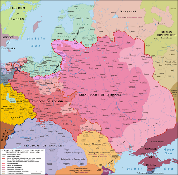
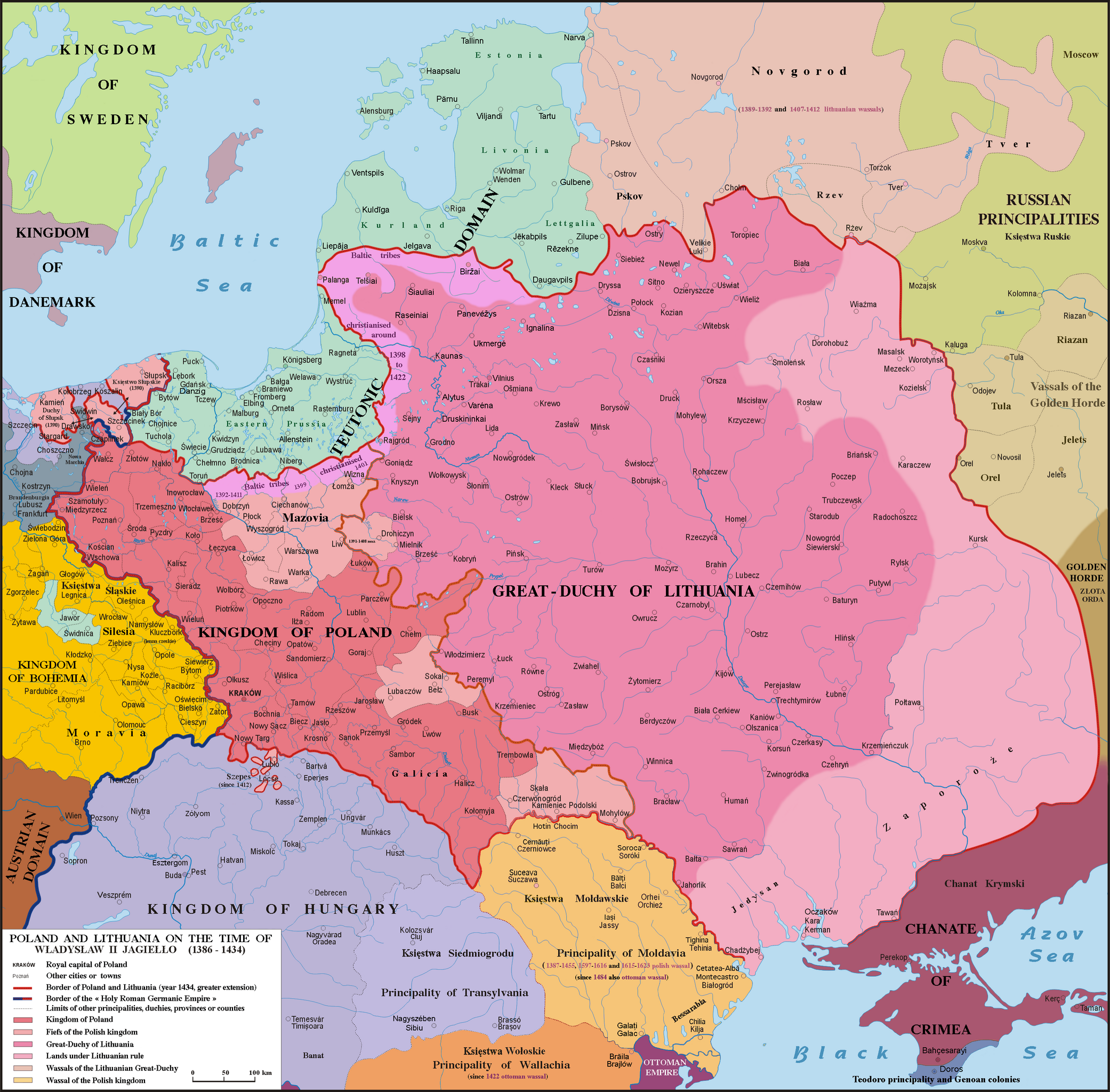
Map of the Grand Duchy of Lithuania (pink) and the Crown of the Kingdom of Poland (red) under the reign of Władysław II Jagiełło (Jogaila) in 1386 - 1434 and neighborhood.
Summary edit
_and_the_Crown_of_the_Kingdom_of_Poland_(red)_and_its_neighborhood_in_1386_%E2%80%93_1434_(English_version).png&action=edit§ion=1)
| Description |
English: Map of Poland, Lithuania & neighbourough 1386-1434. Graphic derivative map since https://fr.wikipedia.org/wiki/Yedisan#/media/File:Polska_1386_-_1434.png but English version and without the 5 mistakes of the original map (impossible to be corrected because the first uploader reverts the new versions) : 1)- Moldavia wasn't a province or a fief (lenno in polish) of the Polish kingdom, but a principality, vassal of Poland from 1387 to 1455, from 1597 to 1616 & from 1615 to 1623 : the Moldavian prince were not a Polish sir appointed by the polish King but a Moldavian boyard elected by the Moldavian Sfat ; 2)- The name Hospodar for the Moldavian princes aren’t in use before the XVIth century ; 3)- In this time Kilja was on the south side of Chilia arm (today Chilia Veche in Romania, not the new Kilija in Ukraine) ; 4)- Danube delta was moldavian till 1484 and the shoreline was different in 1400 ; 5)- Akkerman is not another town but the turkish name (given since 1484) of Bialgorod also named in this time Cetatea-Alba & Montecastro. Sources: Hans-Erich Stier (dir.) "Grosser Atlas zur Weltgeschichte", Ed. Westermann 1985, ISBN 3-14-100919-8, "Történelmi atlasz", Magyar Academy 1991, ISBN 963-351422-3 CM, "Atlas istorico-geografic", Ed. Academica 1994, ISBN 973-27-0500-0, Constantin C. Giurescu & Dinu C. Giurescu :" History of the Romanian lands", Ed. Academica 1985, p.209-210, N. P. Comneanu: "Les principautés roumaines à travers les âges", Ed. Payot, Paris 1919 and Lucian Predescu: "Enciclopedia Cugetarea", p.562-563.
Lietuvių: Lietuvos Didžiosios Kunigaikštystės (rožinė) ir Lenkijos Karalystės Karūnos (raudona) žemėlapis valdant Jogailai 1386 - 1434 m.
Polski: Mapa Polski i Litwy za panowania Władysława II Jagiełły (1386 - 1434). |
| Date | |
| Source | File:Polska 1386 - 1434.png |
| Author |
Poznaniak (original image) Spiridon Ion Cepleanu (derivative work) |
Licensing edit
_and_the_Crown_of_the_Kingdom_of_Poland_(red)_and_its_neighborhood_in_1386_%E2%80%93_1434_(English_version).png&action=edit§ion=2)
I, the copyright holder of this work, hereby publish it under the following license:
This file is licensed under the Creative Commons Attribution-Share Alike 4.0 International license.
- You are free:
- to share – to copy, distribute and transmit the work
- to remix – to adapt the work
- Under the following conditions:
- attribution – You must give appropriate credit, provide a link to the license, and indicate if changes were made. You may do so in any reasonable manner, but not in any way that suggests the licensor endorses you or your use.
- share alike – If you remix, transform, or build upon the material, you must distribute your contributions under the same or compatible license as the original.
File history
Click on a date/time to view the file as it appeared at that time.
| Date/Time | Thumbnail | Dimensions | User | Comment | |
|---|---|---|---|---|---|
| current | 17:18, 10 May 2016 | | 2,977 × 2,929 (2.13 MB) | Julieta39 (talk | contribs) | Teodoro principality in Crimea until 1475 |
| 16:11, 6 December 2015 |  | 2,977 × 2,929 (2.14 MB) | Spiridon Ion Cepleanu (talk | contribs) | Correct orthograph of Lithuania in english | |
| 13:56, 6 December 2015 |  | 2,977 × 2,929 (2.14 MB) | Spiridon Ion Cepleanu (talk | contribs) | User created page with UploadWizard |
You cannot overwrite this file.
File usage on Commons
The following 3 pages use this file:
- Atlas of Poland
- File:Two-nat.Rep 1386-1434.png (file redirect)
File usage on other wikis
The following other wikis use this file:
- Usage on af.wikipedia.org
- Usage on als.wikipedia.org
- Usage on ar.wikipedia.org
- Usage on az.wikipedia.org
- Usage on be.wikipedia.org
- Usage on bg.wikipedia.org
- Usage on br.wikipedia.org
- Usage on ca.wikipedia.org
- Usage on cs.wikipedia.org
- Usage on da.wikipedia.org
- Usage on de.wikipedia.org
- Usage on de.wikibooks.org
- Usage on de.wikiversity.org
- Usage on el.wikipedia.org
- Usage on en.wikipedia.org
- Usage on et.wikipedia.org
- Usage on fa.wikipedia.org
- Usage on fi.wikipedia.org
- Usage on fr.wikipedia.org
- Usage on gd.wikipedia.org
- Usage on hu.wikipedia.org
- Usage on it.wikipedia.org
- Usage on ja.wikipedia.org
- Usage on lt.wikipedia.org
- Usage on lt.wikibooks.org
- Usage on lv.wikipedia.org
View more global usage of this file.
_and_the_Crown_of_the_Kingdom_of_Poland_(red)_and_its_neighborhood_in_1386_%E2%80%93_1434_(English_version).png)
_and_the_Crown_of_the_Kingdom_of_Poland_(red)_and_its_neighborhood_in_1386_–_1434_(English_version).png&oldid=857521735)