File:Map of the Hauran (satellite version)-it.svg

Size of this PNG preview of this SVG file: 647 × 581 pixels. Other resolutions: 267 × 240 pixels | 535 × 480 pixels | 855 × 768 pixels | 1,140 × 1,024 pixels | 2,281 × 2,048 pixels.
Original file (SVG file, nominally 647 × 581 pixels, file size: 2.62 MB)
Captions
Captions
Add a one-line explanation of what this file represents
Summary edit
| Description |
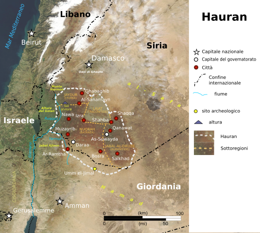
English: Map of the Hauran (satellite version)
Italiano: Mappa della regione Hauran (versione satellitare) |
||
| Date | |||
| Source |
Own work based on: Map of the Hauran (satellite version).svg: |
||
| Author |
|
||
| Other versions |
|
||
| SVG development | This vector image was created with Inkscape. This file uses translateable embedded text.
|
.svg)
-it.svg)
-it.svg&action=edit§ion=1)
-it.svg)
Licensing edit
-it.svg&action=edit§ion=2)
This file is licensed under the Creative Commons Attribution-Share Alike 4.0 International license.
- You are free:
- to share – to copy, distribute and transmit the work
- to remix – to adapt the work
- Under the following conditions:
- attribution – You must give appropriate credit, provide a link to the license, and indicate if changes were made. You may do so in any reasonable manner, but not in any way that suggests the licensor endorses you or your use.
- share alike – If you remix, transform, or build upon the material, you must distribute your contributions under the same or compatible license as the original.
Original upload log edit
-it.svg&action=edit§ion=3)
This image is a derivative work of the following images:
- Map of the Hauran (satellite version).svg licensed with Cc-by-sa-4.0
- 2024-02-22T12:34:06Z Arrow303 647x581 (2981351 Bytes) w/o border
- 2024-02-22T12:32:12Z Arrow303 648x581 (2981686 Bytes) some technical fixes
- 2019-09-12T17:25:00Z Amitchell125 649x579 (4783724 Bytes) minor corrections
- 2019-09-12T07:57:30Z Amitchell125 649x579 (4779327 Bytes) Improved accuracy and readability
- 2019-09-09T22:57:09Z Amitchell125 649x579 (4787682 Bytes) correction
- 2019-09-09T22:42:56Z Amitchell125 649x579 (4787599 Bytes) User created page with UploadWizard
Uploaded with derivativeFX
File history
Click on a date/time to view the file as it appeared at that time.
| Date/Time | Thumbnail | Dimensions | User | Comment | |
|---|---|---|---|---|---|
| current | 13:17, 22 February 2024 | | 647 × 581 (2.62 MB) | Arrow303 (talk | contribs) | colors |
| 13:12, 22 February 2024 |  | 647 × 581 (2.62 MB) | Arrow303 (talk | contribs) | == {{int:filedesc}} == {{Information |Description={{en|1=Map of the Hauran (satellite version)}} {{it|1=Mappa della regione Hauran (versione satellitare)}} |Source={{Derived from|Map of the Hauran (satellite version).svg|display=50}} |Date=2024-02-22 |Author= * File:Map of the Hauran (satellite version).svg: Amitchell125 * {{author|derivative|{{u|Arrow303}}}} |Permission= |other_versions={{G|Map of the Hauran (satellite... |
You cannot overwrite this file.
File usage on Commons
The following 2 pages use this file:
File usage on other wikis
The following other wikis use this file:
- Usage on it.wikipedia.org
-it.svg&oldid=867915095)