File:Map of the Khanate of Kazan.png

Size of this preview: 705 × 600 pixels. Other resolutions: 282 × 240 pixels | 564 × 480 pixels | 903 × 768 pixels | 1,204 × 1,024 pixels | 1,674 × 1,424 pixels.
Original file (1,674 × 1,424 pixels, file size: 43 KB, MIME type: image/png)
Captions
Captions
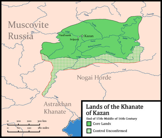
Territories of Kazan, plus neighboring states
Summary edit
| Description |
English: Territories controlled by Kazan at the end of the 16th-middle of the 17th century. Map has neighboring states, cities, rivers and a scale.
Most rivers and the coastline were made with Natural Earth. For the map details and some rivers in Kazan, used Pelenskyj, J. Z. (1974). Russia and Kazan: Conquest and Imperial Ideology (1438-1560s) (Reprint 2017 edition., Vol. 5). De Gruyter, Inc. https://doi.org/10.1515/9783111529899. P.6. |
| Date | |
| Source | Own work |
| Author | HetmanTheResearcher |
Licensing edit
I, the copyright holder of this work, hereby publish it under the following license:
This file is licensed under the Creative Commons Attribution 4.0 International license.
- You are free:
- to share – to copy, distribute and transmit the work
- to remix – to adapt the work
- Under the following conditions:
- attribution – You must give appropriate credit, provide a link to the license, and indicate if changes were made. You may do so in any reasonable manner, but not in any way that suggests the licensor endorses you or your use.
File history
Click on a date/time to view the file as it appeared at that time.
| Date/Time | Thumbnail | Dimensions | User | Comment | |
|---|---|---|---|---|---|
| current | 07:41, 12 January 2024 | | 1,674 × 1,424 (43 KB) | HetmanTheResearcher (talk | contribs) | Uploaded own work with UploadWizard |
You cannot overwrite this file.
File usage on Commons
There are no pages that use this file.
File usage on other wikis
The following other wikis use this file:
- Usage on cs.wikipedia.org
- Usage on en.wikipedia.org