File:Map of the Main Rivers and the Basins in Nagoya City 2023.svg

Size of this PNG preview of this SVG file: 588 × 599 pixels. Other resolutions: 236 × 240 pixels | 471 × 480 pixels | 754 × 768 pixels | 1,005 × 1,024 pixels | 2,010 × 2,048 pixels | 1,967 × 2,004 pixels.
Original file (SVG file, nominally 1,967 × 2,004 pixels, file size: 2.54 MB)
Captions
Captions
Add a one-line explanation of what this file represents
Summary edit
| Description |
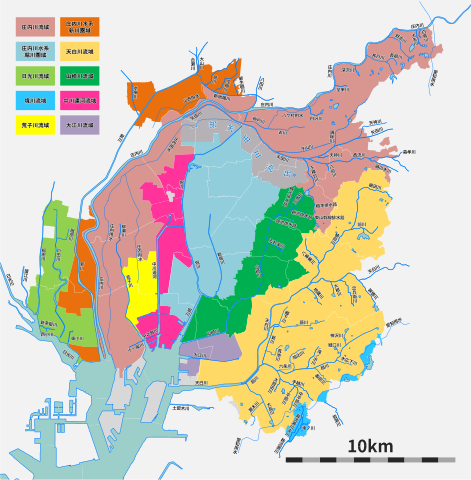
日本語: 名古屋市の主な河川と流域図(『名古屋市都市計画基本図』、『名古屋市総合排水計画』(令和元年5月発行)を元に作成) |
| Date | |
| Source | Own work |
| Author | Tomio344456 |
Licensing edit
I, the copyright holder of this work, hereby publish it under the following license:
This file is licensed under the Creative Commons Attribution-Share Alike 4.0 International license.
- You are free:
- to share – to copy, distribute and transmit the work
- to remix – to adapt the work
- Under the following conditions:
- attribution – You must give appropriate credit, provide a link to the license, and indicate if changes were made. You may do so in any reasonable manner, but not in any way that suggests the licensor endorses you or your use.
- share alike – If you remix, transform, or build upon the material, you must distribute your contributions under the same or compatible license as the original.
File history
Click on a date/time to view the file as it appeared at that time.
| Date/Time | Thumbnail | Dimensions | User | Comment | |
|---|---|---|---|---|---|
| current | 04:51, 29 June 2023 | | 1,967 × 2,004 (2.54 MB) | Tomio344456 (talk | contribs) | Uploaded own work with UploadWizard |
You cannot overwrite this file.
File usage on Commons
There are no pages that use this file.
File usage on other wikis
The following other wikis use this file:
- Usage on ja.wikipedia.org