File:Map of the North West with municipalities named and districts shaded (2016).svg

Size of this PNG preview of this SVG file: 800 × 553 pixels. Other resolutions: 320 × 221 pixels | 640 × 442 pixels | 1,024 × 707 pixels | 1,280 × 884 pixels | 2,560 × 1,768 pixels | 912 × 630 pixels.
Original file (SVG file, nominally 912 × 630 pixels, file size: 598 KB)
Captions
Captions
Add a one-line explanation of what this file represents
Summary
edit.svg&action=edit§ion=1)
| Description |
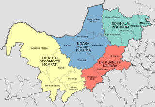
English: Map of the municipalities in the North West province of South Africa, with all municipalities named and district municipalities shaded different colours. |
| Date | |
| Source | Own work; based on File:Map of the North West with municipalities blank (2016).svg |
| Author | Htonl |
.svg)
Licensing
edit.svg&action=edit§ion=2)
I, the copyright holder of this work, hereby publish it under the following licenses:
This file is licensed under the Creative Commons Attribution-Share Alike 3.0 Unported license.
- You are free:
- to share – to copy, distribute and transmit the work
- to remix – to adapt the work
- Under the following conditions:
- attribution – You must give appropriate credit, provide a link to the license, and indicate if changes were made. You may do so in any reasonable manner, but not in any way that suggests the licensor endorses you or your use.
- share alike – If you remix, transform, or build upon the material, you must distribute your contributions under the same or compatible license as the original.

|
Permission is granted to copy, distribute and/or modify this document under the terms of the GNU Free Documentation License, Version 1.2 or any later version published by the Free Software Foundation; with no Invariant Sections, no Front-Cover Texts, and no Back-Cover Texts. A copy of the license is included in the section entitled GNU Free Documentation License. |
You may select the license of your choice.
File history
Click on a date/time to view the file as it appeared at that time.
| Date/Time | Thumbnail | Dimensions | User | Comment | |
|---|---|---|---|---|---|
| current | 15:24, 17 November 2017 | | 912 × 630 (598 KB) | Htonl (talk | contribs) | Rename Venterdorp/Tlokwe to JB Marks |
| 21:07, 4 February 2017 |  | 912 × 630 (603 KB) | Htonl (talk | contribs) | label placement tweak | |
| 21:05, 4 February 2017 |  | 912 × 630 (603 KB) | Htonl (talk | contribs) | == {{int:filedesc}} == {{Information |Description ={{en|1=Map of the municipalities in the North West province of South Africa, with all municipalities named and district municipalities shaded different colours.}} |Source ={{own}}; based on... |
You cannot overwrite this file.
File usage on Commons
There are no pages that use this file.
File usage on other wikis
The following other wikis use this file:
- Usage on en.wikipedia.org
- Usage on et.wikipedia.org
- Usage on frr.wikipedia.org
- Usage on pl.wikipedia.org
- Usage on zh.wikipedia.org
.svg&oldid=489854775)