File:Map of the Spanish Conquest of Guatemala.png
Size of this preview: 552 × 599 pixels. Other resolutions: 221 × 240 pixels | 442 × 480 pixels | 960 × 1,042 pixels.
Original file (960 × 1,042 pixels, file size: 677 KB, MIME type: image/png)
Captions
Captions
Add a one-line explanation of what this file represents

|
This map image could be re-created using vector graphics as an SVG file. This has several advantages; see Commons:Media for cleanup for more information. If an SVG form of this image is available, please upload it and afterwards replace this template with
{{vector version available|new image name}}.
It is recommended to name the SVG file “Map of the Spanish Conquest of Guatemala.svg”—then the template Vector version available (or Vva) does not need the new image name parameter. |
Summary edit
| Description |
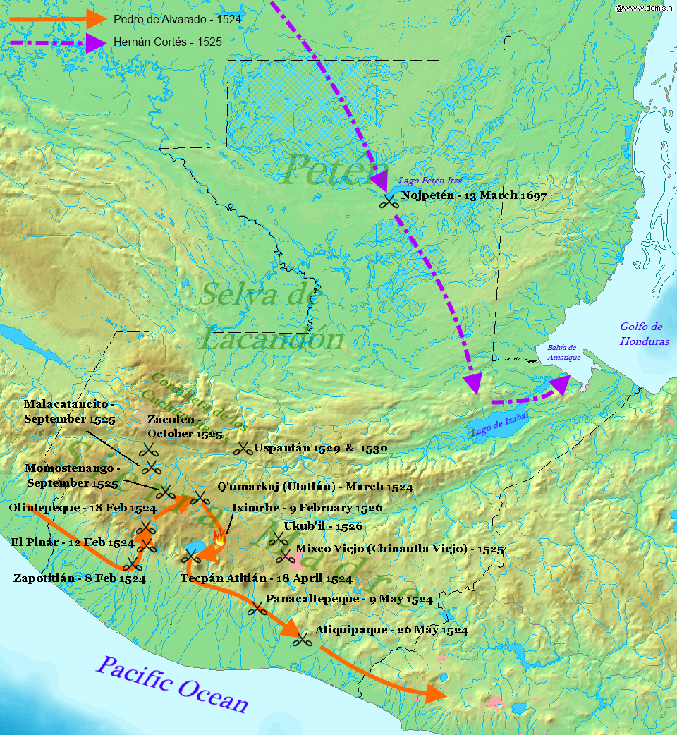
English: Map displaying the principal events of the Spanish Conquest of Guatemala, and the route taken by Pedro de Alvarado. Bounding box West -92.5°, South 13.5°, East -88°, North 18.2°. Center at 15°51′00″N 90°15′00″W / 15.85000°N 90.25000°W. |
| Date | (UTC) |
| Source |
Own work using: |
| Author |
|
| This is a retouched picture, which means that it has been digitally altered from its original version. Modifications: Added battles of the Spanish conquest and geographical locations. The original can be viewed here: Map of Guatemala Demis.png:
|
This file is licensed under the Creative Commons Attribution-Share Alike 3.0 Unported license.
- You are free:
- to share – to copy, distribute and transmit the work
- to remix – to adapt the work
- Under the following conditions:
- attribution – You must give appropriate credit, provide a link to the license, and indicate if changes were made. You may do so in any reasonable manner, but not in any way that suggests the licensor endorses you or your use.
- share alike – If you remix, transform, or build upon the material, you must distribute your contributions under the same or compatible license as the original.
Original upload log edit
This image is a derivative work of the following images:
- File:Map_of_Guatemala_Demis.png licensed with PD-Demis
- 2006-12-20T22:49:24Z Mats Halldin 960x1042 (507761 Bytes) Map of [[Guatemala]] Bounding box West -92.5°, South 13.5°, East -88°, North 18.2°. Center at {{coor d|15.85000|N|90.25000|W|scale:2819999}}. {{demis-pd}} [[category:maps of Guatemala]]
Uploaded with derivativeFX
File history
Click on a date/time to view the file as it appeared at that time.
| Date/Time | Thumbnail | Dimensions | User | Comment | |
|---|---|---|---|---|---|
| current | 22:34, 28 January 2012 | | 960 × 1,042 (677 KB) | Simon Burchell (talk | contribs) | +battles of Momostenango and Malacatancito, move other text make easier to read |
| 20:47, 28 January 2012 |  | 960 × 1,042 (677 KB) | Simon Burchell (talk | contribs) | +battles of Uspantán | |
| 22:11, 5 October 2011 |  | 960 × 1,042 (676 KB) | Simon Burchell (talk | contribs) | Added route of Hernán Cortés 1525 | |
| 21:25, 5 October 2011 |  | 960 × 1,042 (669 KB) | Simon Burchell (talk | contribs) | {{Information |Description=Map of Guatemala Bounding box West -92.5°, South 13.5°, East -88°, North 18.2°. Center at |Source=*File:Map_of_Guatemala_Demis.png |Date=2011-10-05 21:18 (UTC) |Author=*File:Map_of_Guatemala_Demis.png: Demis |
You cannot overwrite this file.
File usage on Commons
The following 2 pages use this file:
File usage on other wikis
The following other wikis use this file:
- Usage on ar.wikipedia.org
- Usage on ca.wikipedia.org
- Usage on en.wikipedia.org
- Usage on es.wikipedia.org
- Usage on fr.wikipedia.org
- Usage on hu.wikipedia.org
- Usage on it.wikipedia.org
- Usage on pnb.wikipedia.org
- Usage on uk.wikipedia.org
- Usage on ur.wikipedia.org
- Usage on vi.wikipedia.org