File:Map of the boundaries of the ADIZ.jpg

Size of this preview: 747 × 599 pixels. Other resolutions: 299 × 240 pixels | 598 × 480 pixels | 840 × 674 pixels.
Original file (840 × 674 pixels, file size: 153 KB, MIME type: image/jpeg)
Captions
Captions
Add a one-line explanation of what this file represents

|
This file has been superseded by North American ADIZ map.png. It is recommended to use the other file. Please note that deleting superseded images requires consent.
|

|
Summary
edit
| Description |
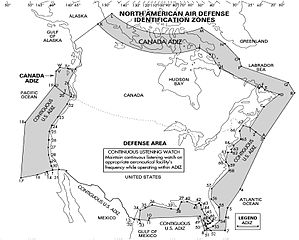
English: ADIZ boundaries from IFR Supplement, United States, 11 Feb 2010, published by Department of Defense, National Geospatial Intelligence Agency. |
| Source | Printed publication, IFR Supplement - United States. |
| Author | Department of Defense |
Licensing
edit
This work is in the public domain in the United States because it is a work prepared by an officer or employee of the United States Government as part of that person’s official duties under the terms of Title 17, Chapter 1, Section 105 of the US Code.
Note: This only applies to original works of the Federal Government and not to the work of any individual U.S. state, territory, commonwealth, county, municipality, or any other subdivision. This template also does not apply to postage stamp designs published by the United States Postal Service since 1978. (See § 313.6(C)(1) of Compendium of U.S. Copyright Office Practices). It also does not apply to certain US coins; see The US Mint Terms of Use.
|
 | |
| This file has been identified as being free of known restrictions under copyright law, including all related and neighboring rights. | ||
Original upload log
edit
The original description page was here. All following user names refer to en.wikipedia.
| Date/Time | Dimensions | User | Comment |
|---|---|---|---|
| 2012-07-20 05:05 | 840×674× (157045 bytes) | Rolypolyman | Uploading a public-domain item using [[Wikipedia:File_Upload_Wizard|File Upload Wizard]] |
File history
Click on a date/time to view the file as it appeared at that time.
| Date/Time | Thumbnail | Dimensions | User | Comment | |
|---|---|---|---|---|---|
| current | 01:24, 26 December 2016 | | 840 × 674 (153 KB) | Iazyges (talk | contribs) | Transferred from en.wikipedia |
You cannot overwrite this file.
File usage on Commons
There are no pages that use this file.
File usage on other wikis
The following other wikis use this file:
- Usage on da.wikipedia.org
- Usage on de.wikipedia.org
- Usage on fr.wikipedia.org
- Usage on th.wikipedia.org
- Usage on zh.wikipedia.org